
Mapa topográfico Reno
Mapa interactivo
Haga clic en el mapa para ver la altitud.
Acerca de este mapa
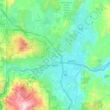
Nombre: Mapa topográfico Reno, altitud, relieve.
Lugar: Reno, Washoe County, Nevada, United States (39.39243 -120.00233 39.72344 -119.69935)
Altitud media: 1.650 m
Altitud mínima: 1.316 m
Altitud máxima: 3.010 m
Reno is just east of the Sierra Nevada, on the western edge of the Great Basin at an elevation of about 4,400 feet (1,300 m) above sea level. Numerous faults exist throughout the region. Most of these are normal (vertical motion) faults associated with the uplift of the various mountain ranges, including the Sierra Nevada.
Otros mapas topográficos
Haga clic en un mapa para ver su topografía, su altitud y su relieve.
Cold Springs
United States > Nevada > Washoe County
Cold Springs, Washoe County, Nevada, 89508, United States
Altitud media: 1.573 m
Nixon
United States > Nevada > Washoe County
Nixon, Washoe County, Nevada, 89424, United States
Altitud media: 1.209 m
Incline Village-Crystal Bay
United States > Nevada > Washoe County
Incline Village-Crystal Bay, Washoe County, Nevada, United States
Altitud media: 2.173 m
Sparks
United States > Nevada > Washoe County
Sparks, Washoe County, Nevada, United States
Altitud media: 1.438 m
Oxbow Nature Study Area
United States > Nevada > Washoe County > Reno > West Reno
Oxbow Nature Study Area, West Reno, Reno, Washoe County, Nevada, United States
Altitud media: 1.415 m
Pyramid Lake
United States > Nevada > Washoe County
Pyramid Lake, Washoe County, Nevada, United States
Altitud media: 1.406 m
North Valley
United States > Nevada > Washoe County > Reno
North Valley, Reno, Washoe County, Nevada, 89512, United States
Altitud media: 1.419 m
New Washoe City
United States > Nevada > Washoe County
New Washoe City, Washoe Valley CCD, Washoe County, Nevada, United States
Altitud media: 1.589 m