
Mapa topográfico Beeston
Mapa interactivo
Haga clic en el mapa para ver la altitud.
Acerca de este mapa
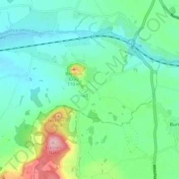
Nombre: Mapa topográfico Beeston, altitud, relieve.
Lugar: Beeston, Cheshire West and Chester, England, United Kingdom (53.11004 -2.72943 53.13742 -2.65961)
Altitud media: 72 m
Altitud mínima: 30 m
Altitud máxima: 198 m
Otros mapas topográficos
Haga clic en un mapa para ver su topografía, su altitud y su relieve.
River Gowy
United Kingdom > England > Cheshire West and Chester > Great Barrow
River Gowy, Great Barrow, Cheshire West and Chester, England, CH3 7RQ, United Kingdom
Altitud media: 43 m
Waverton
United Kingdom > England > Cheshire West and Chester
Waverton, Cheshire West and Chester, North West England, England, United Kingdom
Altitud media: 33 m
Northwich
United Kingdom > England > Cheshire West and Chester
Northwich, Cheshire West and Chester, England, United Kingdom
Altitud media: 30 m
Comberbach
United Kingdom > England > Cheshire West and Chester
Comberbach, Cheshire West and Chester, North West England, England, United Kingdom
Altitud media: 42 m