
Mapa topográfico Kottayam
Mapa interactivo
Haga clic en el mapa para ver la altitud.
Acerca de este mapa
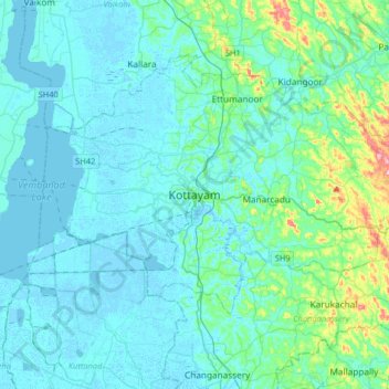
Nombre: Mapa topográfico Kottayam, altitud, relieve.
Lugar: Kottayam, Kottayam District, Kerala, 686001, India (9.43156 76.36216 9.75156 76.68216)
Altitud media: 19 m
Altitud mínima: -4 m
Altitud máxima: 157 m
Kottayam has an average elevation of 3 metres (9.8 ft) above sea level. and is situated in the basin of the Meenachil River and in the basin of the Vembanad backwaters, which are formed from several streams in the Western Ghats in Idukki district. According to the division of places in Kerala based on altitudes, Kottayam is classified as being a midland area. The general soil type is alluvial soil. The vegetation is mainly tropical evergreen and moist deciduous type.
Otros mapas topográficos
Haga clic en un mapa para ver su topografía, su altitud y su relieve.
Thiruvanchoor
India > Kerala > Kottayam > Thiruvanchoor
Thiruvanchoor, Kottayam, Kerala, 686637, India
Altitud media: 11 m
Karappuzha Temple Kulam
India > Kerala > Kottayam > Kottayam
Karappuzha Temple Kulam, Kottayam, Kerala, India
Altitud media: 6 m
Mattakkara
India > Kerala > Kottayam > Mattakkara
Mattakkara, Kottayam, Kerala, 686564, India
Altitud media: 41 m