
Mapa topográfico Sun Valley
Mapa interactivo
Haga clic en el mapa para ver la altitud.
Acerca de este mapa
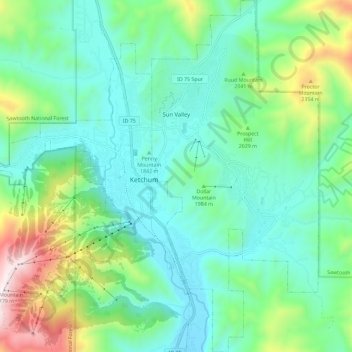
Nombre: Mapa topográfico Sun Valley, altitud, relieve.
Lugar: Sun Valley, Blaine County, Idaho, United States (43.63996 -114.36125 43.72314 -114.30661)
Altitud media: 1.988 m
Altitud mínima: 1.724 m
Altitud máxima: 2.780 m
Sun Valley is a resort city in the western United States, in Blaine County, Idaho, adjacent to the city of Ketchum in the Wood River valley. The population was 1406 at the 2010 census, down from 1427 in 2000. The elevation of Sun Valley (at the Lodge) is 5,920 feet (1,805 m) above sea level.
Otros mapas topográficos
Haga clic en un mapa para ver su topografía, su altitud y su relieve.
Carey
United States > Idaho > Blaine County
Carey, Blaine County, Idaho, 83320, United States
Altitud media: 1.467 m
Ketchum
United States > Idaho > Blaine County
Ketchum, Blaine County, Idaho, United States
Altitud media: 1.906 m
Titus Lake
United States > Idaho > Blaine County
Titus Lake, Blaine County, Idaho, United States
Altitud media: 2.736 m
Bellevue
United States > Idaho > Blaine County
Bellevue, Blaine County, Idaho, 83313, United States
Altitud media: 1.667 m
Hailey
United States > Idaho > Blaine County
Hailey, Blaine County, Idaho, 83333, United States
Altitud media: 1.729 m