
Mapa topográfico Quezon City
Mapa interactivo
Haga clic en el mapa para ver la altitud.
Quezon City
Founded as a pueblo by Saint Pedro Bautista in 1590, San Francisco del Monte may be considered Quezon City's oldest district. The original land area of the old town of San Francisco del Monte was approximately2.5 square kilometres (1.0 sq mi) and covered parts of what is currently known as Project 7 and 8 and Timog Avenue. It was later absorbed by Quezon City. It featured a hilly topography with lush vegetation and mineral springs, in the midst of which the old Santuario de San Pedro Bautista was built as a retreat and monastery for Franciscan friars.
Acerca de este mapa
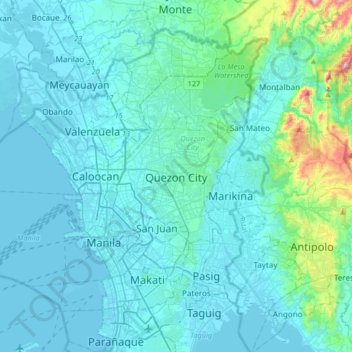
Nombre: Mapa topográfico Quezon City, altitud, relieve.
Altitud media: 57 m
Altitud mínima: -3 m
Altitud máxima: 581 m
Otros mapas topográficos
Haga clic en un mapa para ver su topografía, su altitud y su relieve.
Central
In order to make Quezon's dream a reality and to mobilize funds for the land purchase, the People's Homesite Corporation (PHC) was created on October 14, 1938, as a subsidiary of NDC, with an initial capital of ₱2 million. Roces was the chairman of the Board of PHC, and they immediately acquired the vast…
Altitud media: 50 m
La Mesa Eco Park
Covering an area of 33 hectares (82 acres) the public park is located along the natural boundary of the La Mesa Watershed Reservation and its elevation is about 40 metres (130 ft) below than the resorvoir.
Altitud media: 66 m
La Mesa Eco Park
Covering an area of 33 hectares (82 acres) the public park is located along the natural boundary of the La Mesa Watershed Reservation and its elevation is about 40 metres (130 ft) below than the reservoir.
Altitud media: 66 m