
Haz una donación
Mapa topográfico Mandurah
Haga clic en el mapa para ver la altitud.
Haz una donación
Acerca de este mapa
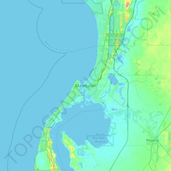
Nombre: Mapa topográfico Mandurah, altitud, relieve.
Altitud media: 5 m
Altitud mínima: -4 m
Altitud máxima: 60 m
Haz una donación
Otros mapas topográficos
Haga clic en un mapa para ver su topografía, su altitud y su relieve.
Haz una donación
Haz una donación
Ellenbrook
The suburb sits in the south-east corner of the Gnangara Mound, close to the Darling Scarp. Topographically, the majority of Ellenbrook's area sits between 40-50 metres above sea level on the mound, with parts of Coolamon and Malvern Springs situated on hills that reach peaks of 65 metres. The northern village…
Altitud media: 49 m
Haz una donación
Haz una donación
Haz una donación
Katanning
Katanning railway station has an elevation of 1,024 feet (312 m) above sea level and a rail distance of 225 miles (362 km) from Perth.
Altitud media: 323 m
Haz una donación
Haz una donación
Haz una donación
Haz una donación
Haz una donación
Haz una donación
Tom Price
Tom Price is the closest town to Karijini National Park and is serviced by the nearby Paraburdoo Airport. Due to its elevation (747 m (2,451 ft)), temperatures are lowered and rainfall is intensified, resulting in the town possessing a subtropical semi-arid climate (Köppen: BSh). Summers are very hot with…
Altitud media: 791 m
Haz una donación
Haz una donación
Haz una donación
Haz una donación
Haz una donación
Haz una donación
Haz una donación
Haz una donación
Haz una donación
Haz una donación
Haz una donación
Haz una donación
Haz una donación
Haz una donación