
Mapa topográfico Meredith
Mapa interactivo
Haga clic en el mapa para ver la altitud.
Acerca de este mapa
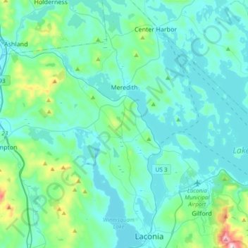
Nombre: Mapa topográfico Meredith, altitud, relieve.
Altitud media: 215 m
Altitud mínima: 142 m
Altitud máxima: 718 m
According to the United States Census Bureau, the town has a total area of 54.6 square miles (141.3 km2), of which 40.1 square miles (103.8 km2) are land and 14.5 square miles (37.5 km2), or 26.37%, are water. The highest point in Meredith is the summit of Leavitt Mountain, elevation 1,414 feet (431 m) above sea level, in the southwestern part of town.
Otros mapas topográficos
Haga clic en un mapa para ver su topografía, su altitud y su relieve.
Winnisquam
United States > New Hampshire > Belknap County > Tilton
Winnisquam, Tilton, Belknap County, New Hampshire, 03289, United States
Altitud media: 175 m
Glendale
United States > New Hampshire > Belknap County > Gilford
Glendale, Gilford, Belknap County, New Hampshire, 03249, United States
Altitud media: 181 m
Weirs Beach
United States > New Hampshire > Belknap County > Laconia > Interlaken Park
Weirs Beach, Interlaken Park, Laconia, Belknap County, New Hampshire, 03247, United States
Altitud media: 179 m
Lakeport
United States > New Hampshire > Belknap County > Laconia
Lakeport, Laconia, Belknap County, New Hampshire, 03246, United States
Altitud media: 180 m
Squam Lake
United States > New Hampshire > Belknap County > Center Harbor
Squam Lake, Center Harbor, Belknap County, New Hampshire, United States
Altitud media: 220 m
Hopkinson Hill
United States > New Hampshire > Belknap County > Sanbornton
Hopkinson Hill, Sanbornton, Belknap County, New Hampshire, 03269, United States
Altitud media: 292 m
Lake Manning
United States > New Hampshire > Belknap County > Gilmanton
Lake Manning, Gilmanton, Belknap County, New Hampshire, United States
Altitud media: 248 m
Sunset Lake
United States > New Hampshire > Belknap County > Alton
Sunset Lake, Alton, Belknap County, New Hampshire, United States
Altitud media: 268 m
Gilford
United States > New Hampshire > Belknap County
Gilford, Belknap County, New Hampshire, 03249, United States
Altitud media: 231 m
Laconia
United States > New Hampshire > Belknap County
Laconia, Belknap County, New Hampshire, United States
Altitud media: 203 m
Sanbornton
United States > New Hampshire > Belknap County
Sanbornton, Belknap County, New Hampshire, 03269, United States
Altitud media: 228 m
Governors Island
United States > New Hampshire > Belknap County > Gilford > Dockham Shore
Governors Island, Dockham Shore, Gilford, Belknap County, New Hampshire, United States
Altitud media: 162 m
Alton
United States > New Hampshire > Belknap County
Alton, Belknap County, New Hampshire, United States
Altitud media: 235 m
Lochmere
United States > New Hampshire > Belknap County > Belmont
Lochmere, Belmont, Belknap County, New Hampshire, 03252, United States
Altitud media: 173 m
Adams Pond;Adams Pond Dam
United States > New Hampshire > Belknap County > Alton
Adams Pond;Adams Pond Dam, Alton, Belknap County, New Hampshire, 03809, United States
Altitud media: 252 m
Gilmanton Ironworks
United States > New Hampshire > Belknap County > Gilmanton
Gilmanton Ironworks, Gilmanton, Belknap County, New Hampshire, 03837, United States
Altitud media: 224 m
Gilmanton
United States > New Hampshire > Belknap County
Gilmanton, Belknap County, New Hampshire, United States
Altitud media: 257 m
Welch Island
United States > New Hampshire > Belknap County > Gilford
Welch Island, Gilford, Belknap County, New Hampshire, United States
Altitud media: 153 m
Gunstock Mountain
United States > New Hampshire > Belknap County > Gilford
Gunstock Mountain, Gilford, Belknap County, New Hampshire, 03249, United States
Altitud media: 456 m
Center Harbor
United States > New Hampshire > Belknap County
Center Harbor, Belknap County, New Hampshire, United States
Altitud media: 214 m
Yale Estates
United States > New Hampshire > Belknap County > Gilford > Yale Estates
Yale Estates, Gilford, Belknap County, New Hampshire, United States
Altitud media: 390 m
Laconia
United States > New Hampshire > Belknap County > Laconia
Laconia, Belknap County, New Hampshire, 03246, United States
Altitud media: 227 m
Winona
United States > New Hampshire > Belknap County > New Hampton > Winona
Winona, New Hampton, Belknap County, New Hampshire, United States
Altitud media: 232 m
Tilton
United States > New Hampshire > Belknap County
Tilton, Belknap County, New Hampshire, United States
Altitud media: 196 m
Center Barnstead
United States > New Hampshire > Belknap County > Barnstead
Center Barnstead, Barnstead, Belknap County, New Hampshire, 03218, United States
Altitud media: 183 m
New Hampton
United States > New Hampshire > Belknap County
New Hampton, Belknap County, New Hampshire, 03256, United States
Altitud media: 264 m
Belmont
United States > New Hampshire > Belknap County
Belmont, Belknap County, New Hampshire, United States
Altitud media: 232 m
Belknap Mountain
United States > New Hampshire > Belknap County > Gilford
Belknap Mountain, Gilford, Belknap County, New Hampshire, 03249, United States
Altitud media: 498 m
Alton Bay
United States > New Hampshire > Belknap County > Alton
Alton Bay, Alton, Belknap County, New Hampshire, 03809, United States
Altitud media: 226 m