
Mapa topográfico Rickman
Mapa interactivo
Haga clic en el mapa para ver la altitud.
Acerca de este mapa
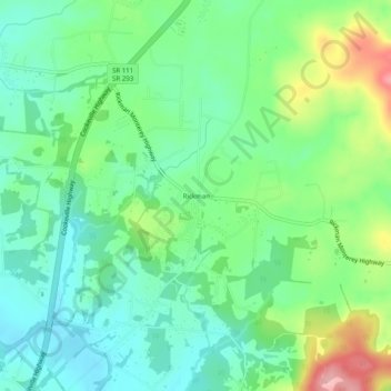
Nombre: Mapa topográfico Rickman, altitud, relieve.
Altitud media: 333 m
Altitud mínima: 284 m
Altitud máxima: 443 m
Otros mapas topográficos
Haga clic en un mapa para ver su topografía, su altitud y su relieve.
Livingston
United States > Tennessee > Overton County
According to the United States Census Bureau, the town has a total area of 5.2 square miles (13 km2), of which 5.1 square miles (13 km2) is land and 0.04 square miles (0.10 km2) (0.77%) is water. Elevation in the town ranges from 1,027 ft (313 m) to 1700 ft (518.16 m)
Altitud media: 349 m