
Mapa topográfico Machilipatnam
Mapa interactivo
Haga clic en el mapa para ver la altitud.
Acerca de este mapa
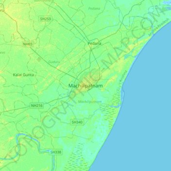
Nombre: Mapa topográfico Machilipatnam, altitud, relieve.
Lugar: Machilipatnam, Krishna, Andhra Pradesh, 521001, India (16.02174 80.97482 16.34174 81.29482)
Altitud media: 4 m
Altitud mínima: -4 m
Altitud máxima: 13 m
Machilipatnam city is at 16°10′N 81°08′E / 16.17°N 81.13°E / 16.17; 81.13 on the southeast coast of India and in the east coast of Andhra Pradesh. The city has an average elevation of 14 meters (45 feet).