
Mapa topográfico Bury St Edmunds
Mapa interactivo
Haga clic en el mapa para ver la altitud.
Bury St Edmunds
The name Bury is etymologically connected with borough, which has cognates in other Germanic languages such as the German burg meaning "fortress, castle"; Old Norse borg meaning "wall, castle"; and Gothic baurgs meaning "city". They all derive from Proto-Germanic *burgs meaning "fortress". This in turn derives from the Proto-Indo-European root *bhrgh meaning "fortified elevation", with cognates including Welsh bera ("stack") and Sanskrit bhrant- ("high, elevated building").
Acerca de este mapa
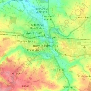
Nombre: Mapa topográfico Bury St Edmunds, altitud, relieve.
Altitud media: 59 m
Altitud mínima: 21 m
Altitud máxima: 107 m