
Mapa topográfico Schefferville
Mapa interactivo
Haga clic en el mapa para ver la altitud.
Schefferville
The cold winters are caused in part by elevation, and in part the ice cover of Hudson Bay eliminating maritime moderation in winter. Although Schefferville is nearer the Atlantic, the cold Labrador Current brings cold air also from the east. In summer, the Hudson Bay water is cold after just thawing, and the Labrador waters remains cool and prone to low-pressure systems under the Icelandic Low. As a result, even the vast landmass seldom builds up heat and remains extremely chilly for the latitude. Areas on similar or higher latitudes in western Canada are much warmer also in this time of the year as a result. The low mean annual air temperature of -5.3 °C indicates widespread occurrences of permafrost.
Acerca de este mapa
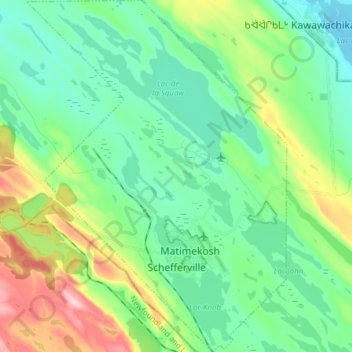
Nombre: Mapa topográfico Schefferville, altitud, relieve.
Altitud media: 537 m
Altitud mínima: 476 m
Altitud máxima: 699 m
Otros mapas topográficos
Haga clic en un mapa para ver su topografía, su altitud y su relieve.