
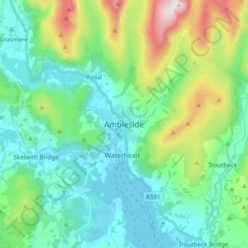
Mapa topográfico Ambleside
Mapa interactivo
Haga clic en el mapa para ver la altitud.
Acerca de este mapa
Nombre: Mapa topográfico Ambleside, altitud, relieve.
Altitud media: 212 m
Altitud mínima: 37 m
Altitud máxima: 774 m
Otros mapas topográficos
Haga clic en un mapa para ver su topografía, su altitud y su relieve.
Wharton Tarn
United Kingdom > England > Westmorland and Furness > Hawkshead > Hawkshead Hill
Altitud media: 173 m
Newton Tarn
United Kingdom > England > Westmorland and Furness > High Newton > Low Newton
Altitud media: 102 m
Brothers Water
United Kingdom > England > Westmorland and Furness > Patterdale > Hartsop
Altitud media: 298 m
Three Dubs Tarn
United Kingdom > England > Westmorland and Furness > Bowness-on-Windermere
Altitud media: 156 m
School Knott Tarn
United Kingdom > England > Westmorland and Furness > Windermere
Altitud media: 168 m
Knipe Tarn
United Kingdom > England > Westmorland and Furness > Winster > Mitchelland
Altitud media: 131 m
Howgill Fells
United Kingdom > England > Westmorland and Furness > Ravenstonedale
Altitud media: 303 m
River Glenderamackin
United Kingdom > England > Westmorland and Furness > Threlkeld
Altitud media: 346 m
Mallerstang Edge
United Kingdom > England > Westmorland and Furness > Mallerstang
Altitud media: 489 m
Scout Scar
United Kingdom > England > Westmorland and Furness > Brigsteer
Scout Scar, also called Underbarrow Scar, is a hill in the English Lake District, west of Kendal, Cumbria and above the village of Underbarrow. It reaches 771 feet (235 m). Scout Scar is the subject of a chapter of Wainwright's book The Outlying Fells of Lakeland, but the summit he describes is a lower summit…
Altitud media: 130 m
Roudsea Wood
United Kingdom > England > Westmorland and Furness > South Lakeland > Haverthwaite
Altitud media: 7 m
Deepdale Beck
United Kingdom > England > Westmorland and Furness > South Lakeland > Dent
Altitud media: 280 m