
Mapa topográfico County Donegal
Mapa interactivo
Haga clic en el mapa para ver la altitud.
Acerca de este mapa
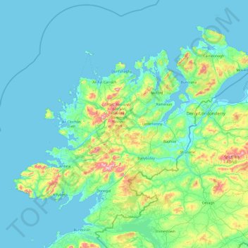
Nombre: Mapa topográfico County Donegal, altitud, relieve.
Lugar: County Donegal, Ulster, Ireland (54.45905 -8.83471 55.43530 -6.92273)
Altitud media: 74 m
Altitud mínima: -4 m
Altitud máxima: 697 m
The majority of Donegal has a temperate oceanic climate (Köppen climate classification: Cfb), with upland areas in the Derryveagh and Blue Stack ranges classified as oceanic subpolar (Köppen climate classification: Cfc). The county's climate is heavily influenced by the North Atlantic Current. Due to the topography of western Donegal, it receives orographic rainfall, where the air is forced to rise on contact with its mountainous coastline and subsequently cools and condenses, forming clouds. The mountains of Donegal are among the cloudiest places in Ireland, and northern Donegal is the windiest. Irish monthly record wind speeds for March, June, July, September, November and December have all been set at Malin Head. The highest wind speed ever recorded in Donegal was 181 km/h (112 mph) on 16 September 1961, during Hurricane Debbie.
Otros mapas topográficos
Haga clic en un mapa para ver su topografía, su altitud y su relieve.
Ballyseedy Wood
Ballyseedy Wood, Ballyseedy ED, Tralee Municipal District, County Kerry, Munster, Ireland
Altitud media: 20 m
Dromore West
Dromore West, Ballymote-Tubbercurry Municipal District, County Sligo, Connacht, Ireland
Altitud media: 51 m
Johnstown
Johnstown, The Municipal District of Naas, County Kildare, Leinster, W91 Y3CP, Ireland
Altitud media: 97 m
Conaghy
Conaghy, Killeevan ED, Ballybay-Clones Municipal District, County Monaghan, Ulster, Ireland
Altitud media: 67 m
Cloonkeenkerrill
Cloonkeenkerrill, Colmanstown ED, Ballinasloe Municipal District, County Galway, Connacht, Ireland
Altitud media: 88 m
Colmanstown
Colmanstown, Killofin ED, West Clare Municipal District, County Clare, Munster, Ireland
Altitud media: 24 m
Gort
Gort, Loughrea Municipal District, County Galway, Connacht, H91 R5F9, Ireland
Altitud media: 27 m
Morristown
Morristown, Rathmore ED, The Municipal District of Naas, County Kildare, Leinster, Ireland
Altitud media: 113 m
Galway City
Galway, Galway City, County Galway, Connacht, H91 YD86, Ireland
Altitud media: 26 m
Kilkenny
Kilkenny, The Municipal District of Kilkenny City, County Kilkenny, Leinster, Ireland
Altitud media: 61 m
Ballincollig
Ireland > County Cork > Cork
Ballincollig, Cork, County Cork, Munster, P31 TW88, Ireland
Altitud media: 62 m
Cordarragh
Cordarragh, Headford ED, Tuam Municipal District, County Galway, Connacht, Ireland
Altitud media: 20 m
Comeragh
Comeragh, The Municipal District of Comeragh, County Waterford, Munster, Ireland
Altitud media: 215 m
Sligo
Sligo, Sligo Municipal Borough District, County Sligo, Connacht, Ireland
Altitud media: 21 m
Adare
Ireland > County Limerick > The Municipal District of Adare — Rathkeale
Adare, The Municipal District of Adare — Rathkeale, County Limerick, Munster, Ireland
Altitud media: 12 m
Lanesborough
Lanesborough, Ballymahon Municipal District, County Longford, Leinster, Ireland
Altitud media: 41 m
Curraghboy
Curraghboy, Rockhill Electoral Division, Athlone Municipal District, County Roscommon, Connacht, N37 EK20, Ireland
Altitud media: 69 m
Summerhill
Summerhill, Summerhill ED, The Municipal District of Trim, County Meath, Leinster, Ireland
Altitud media: 86 m
Gorteennakilla
Gorteennakilla, Youghalarra, The Municipal District of Nenagh, County Tipperary, Munster, Ireland
Altitud media: 57 m
Kilcurriv Eighter
Kilcurriv Eighter, Killower ED, Tuam Municipal District, County Galway, Connacht, Ireland
Altitud media: 48 m
Cahir
Cahir, The Municipal District of Cahir — Cashel, County Tipperary, Munster, Ireland
Altitud media: 58 m
Callanagh Lower
Callanagh Lower, Drumlumman ED, Ballyjamesduff Municipal District, County Cavan, Ulster, Ireland
Altitud media: 85 m
Ballyhaunis
Ballyhaunis, Claremorris-Swinford Municipal District, County Mayo, Connacht, F35 NF82, Ireland
Altitud media: 87 m
Mount Lucas
Mount Lucas, Esker ED, The Municipal District of Edenderry, County Offaly, Leinster, R35 XW10, Ireland
Altitud media: 76 m
Lough Bane
Lough Bane, Crosskeys ED, The Municipal District of Kells, County Westmeath, County Meath, Leinster, Ireland
Altitud media: 130 m
Lettermore
Lettermore, Lettermore ED, Conamara Municipal District, County Galway, Connacht, Ireland
Altitud media: 8 m
Upper Lough Bray
Upper Lough Bray, Powerscourt ED, The Municipal District of Bray, County Wicklow, Leinster, Ireland
Altitud media: 496 m
Broadlough
Broadlough, Ardee Rural ED, The Municipal District of Ardee, County Louth, Leinster, Ireland
Altitud media: 34 m
Moorock
Moorock, Ballycumber ED, The Municipal District of Tullamore, County Offaly, Leinster, Ireland
Altitud media: 64 m
Barnadown
Barnadown, Aghaviller, The Municipal District of Callan — Thomastown, County Kilkenny, Leinster, Ireland
Altitud media: 212 m
Shronowen
Shronowen, Shronowen ED, Listowel Municipal District, County Kerry, Munster, Ireland
Altitud media: 27 m
Pembrokestown
Pembrokestown, Waterford City Metropolitan District, County Waterford, Munster, X91 R6CA, Ireland
Altitud media: 57 m
Smithstown
Smithstown, Ballinlough ED, The Municipal District of Kells, County Meath, Leinster, Ireland
Altitud media: 121 m
Ballinaclogh
Ballinaclogh, Glenealy ED, The Municipal District of Wicklow, County Wicklow, Leinster, Ireland
Altitud media: 108 m
Pollduff
Pollduff, Loughrea Municipal District, County Galway, Connacht, Ireland
Altitud media: 219 m
Kiltole
Kiltole, Figart ED, Lifford-Stranorlar Municipal District, County Donegal, Ireland
Altitud media: 49 m
Durrow
Durrow, The Municipal District of Tullamore, County Offaly, Leinster, R35 X865, Ireland
Altitud media: 66 m
Inchigeelagh
Inchigeelagh, Municipal District of Macroom, County Cork, Munster, P12 W864, Ireland
Altitud media: 135 m