Geolocalizar

Mapa topográfico Isle of Anglesey

Mapa interactivo

Haga clic en el mapa para ver la altitud.

Acerca de este mapa

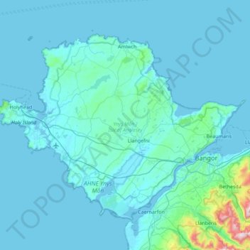
Nombre: Mapa topográfico Isle of Anglesey, altitud, relieve.

Lugar: Isle of Anglesey, Wales, United Kingdom (53.12622 -4.69671 53.43580 -4.01903)

Altitud media: 49 m

Altitud mínima: -1 m

Altitud máxima: 988 m

Otros mapas topográficos

Haga clic en un mapa para ver su topografía, su altitud y su relieve.

Swansea

United Kingdom > Wales > Swansea

Much of Swansea is hilly with the main area of upland being located in the council ward of Mawr. Areas up to 185 metres (607 ft) in elevation range across the central section: Kilvey Hill, Townhill and Llwynmawr separate the centre of Swansea from its northern suburbs. Cefn Bryn, a ridge of high land, is the…

Altitud media: 73 m

Porthmadog

United Kingdom > Wales > Gwynedd

Altitud media: 43 m

Cardiff

United Kingdom > Wales > Cardiff

Altitud media: 55 m

Cambrian Mountains

United Kingdom > Wales > Powys

Altitud media: 319 m

Snowdon

United Kingdom > Wales > Gwynedd

Snowdon (/ˈsnoʊdən/) or Yr Wyddfa (pronounced [ər ˈʊɨ̞̯ðva] (listen)), is the highest mountain in Wales, at an elevation of 1,085 metres (3,560 ft) above sea level, and the highest point in the British Isles outside the Scottish Highlands. It is located in Snowdonia National Park (Parc Cenedlaethol…

Altitud media: 692 m

Rhosymedre

United Kingdom > Wales > Wrexham

Altitud media: 126 m

Monmouth

United Kingdom > Wales > Monmouthshire

Altitud media: 101 m

Govilon

United Kingdom > Wales > Monmouthshire

Altitud media: 186 m

Adam and Eve

United Kingdom > Wales > Conwy

Altitud media: 555 m

Penrhos

United Kingdom > Wales > Monmouthshire

Altitud media: 79 m

Llanteg

United Kingdom > Wales > Pembrokeshire

Altitud media: 137 m

Llangollen

United Kingdom > Wales > Denbighshire

Altitud media: 279 m

Llanelli

United Kingdom > Wales > Carmarthenshire

Altitud media: 41 m

Beaufort

United Kingdom > Wales > Blaenau Gwent

Altitud media: 384 m

Yr Elen

United Kingdom > Wales > Gwynedd

Altitud media: 700 m

Crib Goch

United Kingdom > Wales > Gwynedd

Altitud media: 556 m

Aberystwyth

United Kingdom > Wales > Ceredigion

Aberystwyth experiences an oceanic climate (Köppen climate classification Cfb) similar to almost all of the United Kingdom. This is particularly pronounced due to its west coast location facing the Irish Sea. Air undergoes little land moderation and so temperatures closely reflect the sea temperature when…

Altitud media: 39 m

Dolfor

United Kingdom > Wales > Powys

Altitud media: 330 m

River Dee

United Kingdom > Wales > Denbighshire > Corwen > Bonwm

Altitud media: 244 m

Talybont-on-Usk

United Kingdom > Wales > Powys

Altitud media: 197 m

Abergavenny

United Kingdom > Wales > Monmouthshire

Altitud media: 187 m

Cardiff

United Kingdom > Wales > Cardiff

Altitud media: 55 m

Dyserth

United Kingdom > Wales > Denbighshire

Altitud media: 90 m

Dinas

United Kingdom > Wales > Rhondda Cynon Taf

Altitud media: 221 m

Newport

United Kingdom > Wales > Newport

Altitud media: 89 m

Wrexham

United Kingdom > Wales > Wrexham

Altitud media: 139 m

Brecon

United Kingdom > Wales > Powys

Altitud media: 216 m

River Taff

United Kingdom > Wales > Cardiff > Pontypridd

Altitud media: 12 m

Caego

United Kingdom > Wales > Wrexham

Altitud media: 121 m

Upper Gronant

United Kingdom > Wales > Flintshire

Altitud media: 76 m

Llandinam

United Kingdom > Wales > Powys

Altitud media: 221 m

Llanfechain

United Kingdom > Wales > Powys

Altitud media: 146 m

Cymmer

United Kingdom > Wales > Neath Port Talbot

Altitud media: 293 m

Yr Aran

United Kingdom > Wales > Gwynedd

Yr Aran is a mountain peak on a ridge radiating south from Snowdon, Wales' highest mountain, with views of the summit of Snowdon, Moel Hebog and the Nantlle Ridge. It has an elevation of 747.2 m (2,451 ft) and a prominence of 235 m (771 ft).

Altitud media: 440 m

Tywyn

United Kingdom > Wales > Gwynedd

In Samuel Lewis's A Topographical Dictionary of Wales (1833) it is reported that popular horse races were held on land to the north of the town every September. Between 1904 and 1947, Towyn Golf Club (originally the Towyn-on-Sea Golf Club) was also located on land to the north of the town.

Altitud media: 50 m

Wrexham

United Kingdom > Wales > Wrexham

Altitud media: 139 m

Four Crosses

United Kingdom > Wales > Powys

Altitud media: 73 m

Moel Siabod

United Kingdom > Wales > Conwy

Altitud media: 532 m

Llanfyllin

United Kingdom > Wales > Powys

Altitud media: 208 m

Dutlas

United Kingdom > Wales > Powys

Altitud media: 315 m

Tintern

United Kingdom > Wales > Monmouthshire

Altitud media: 139 m

Knighton

United Kingdom > Wales > Powys

The town became a borough in 1203, with a charter permitting a weekly market and annual fair. The presence of two castles within a comparatively small town suggests that one (the earlier motte and bailey sited atop the town) went out of use before the establishment of the second (the motte with no bailey at…

Altitud media: 295 m

Cwmdare

United Kingdom > Wales > Rhondda Cynon Taf

Altitud media: 232 m

Penley

United Kingdom > Wales > Wrexham

Altitud media: 66 m

Domgay

United Kingdom > Wales > Powys

Altitud media: 65 m

Nantgwynant

United Kingdom > Wales > Gwynedd > Beddgelert

Altitud media: 264 m

Cwmbrân

United Kingdom > Wales > Torfaen

Altitud media: 138 m

Allt Y Main

United Kingdom > Wales > Powys

Altitud media: 179 m

Meliden

United Kingdom > Wales > Denbighshire

Altitud media: 71 m

Beguildy

United Kingdom > Wales > Powys

Altitud media: 332 m

Kinnerton

United Kingdom > Wales > Powys

Altitud media: 262 m

Salem

United Kingdom > Wales > Carmarthenshire

Altitud media: 140 m

Cefn

United Kingdom > Wales > Wrexham > Bryn Cefn

Altitud media: 160 m

Cymmer

United Kingdom > Wales > Rhondda Cynon Taf

Altitud media: 227 m

Varteg

United Kingdom > Wales > Torfaen

Altitud media: 352 m

Snowdon

United Kingdom > Wales > Gwynedd

Snowdon (/ˈsnoʊdən/), or Yr Wyddfa (Welsh: [ər ˈʊɨ̞̯ðva] ), is a mountain in Snowdonia in North Wales. It has an elevation of 1,085 metres (3,560 ft) above sea level, which makes it both the highest mountain in Wales and the highest in the British Isles south of the Scottish Highlands. Snowdon is…

Altitud media: 692 m

Gorslas

United Kingdom > Wales > Carmarthenshire

Altitud media: 174 m

Monmouth

United Kingdom > Wales > Monmouthshire

Altitud media: 101 m

Cwm-Cou

United Kingdom > Wales > Ceredigion

Altitud media: 90 m

Llanwern

United Kingdom > Wales > Newport

Altitud media: 26 m

Plynlimon

United Kingdom > Wales > Ceredigion

Altitud media: 583 m

Caim

United Kingdom > Wales > Isle of Anglesey > Llangoed

Altitud media: 21 m

Rhos-y-gwaliau

United Kingdom > Wales > Gwynedd > Llangywer

Altitud media: 246 m

Buckley

United Kingdom > Wales > Flintshire

Altitud media: 109 m

Llanwern

United Kingdom > Wales > Newport

Altitud media: 26 m

Bodfari

United Kingdom > Wales > Denbighshire

Altitud media: 88 m

Llawhaden

United Kingdom > Wales > Pembrokeshire

Altitud media: 57 m

Ffrith

United Kingdom > Wales > Flintshire

Altitud media: 211 m

Nantmel

United Kingdom > Wales > Powys

Altitud media: 269 m

Shotton

United Kingdom > Wales > Flintshire

Altitud media: 37 m

Rhyd-ddu

United Kingdom > Wales > Gwynedd

Altitud media: 290 m

Porth

United Kingdom > Wales > Rhondda Cynon Taf

Altitud media: 226 m

Garnedd Ugain

United Kingdom > Wales > Gwynedd

Garnedd Ugain, the summit of Crib-y-Ddysgl ridge, is a pyramidal mountain in Wales that forms part of the Snowdon Massif. It is the second-highest peak in Wales (although with a far greater topographical prominence Carnedd Llywelyn is usually considered second highest) and lies just under one kilometre north…

Altitud media: 678 m

Gogarth

United Kingdom > Wales > Conwy > Llandudno

Altitud media: 27 m

Carnedd Llewelyn

United Kingdom > Wales > Conwy

Altitud media: 790 m

Crymych

United Kingdom > Wales > Pembrokeshire

Altitud media: 225 m

Wenvoe

United Kingdom > Wales > Vale of Glamorgan

Altitud media: 72 m