
Mapa topográfico Hastings County
Haga clic en el mapa para ver la altitud.
Acerca de este mapa
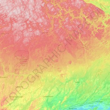
Nombre: Mapa topográfico Hastings County, altitud, relieve.
Lugar: Hastings County, Central Ontario, Ontario, Canada (44.14764 -78.17764 45.43808 -77.03308)
Altitud media: 288 m
Altitud mínima: 72 m
Altitud máxima: 545 m
Otros mapas topográficos
Haga clic en un mapa para ver su topografía, su altitud y su relieve.
Toronto
Despite its deep ravines, Toronto is not remarkably hilly, but its elevation does increase steadily away from the lake. Elevation differences range from 76.5 metres (251 ft) above sea level at the Lake Ontario shore to 209 m (686 ft) ASL near the York University grounds in the city's north end at the…
Altitud media: 113 m
London
Canada > Ontario > London > London
London has a humid continental climate (Köppen Dfb), though due to its downwind location relative to Lake Huron and elevation changes across the city, it is virtually on the Dfa/Dfb (hot summer) boundary favouring the former climate zone to the southwest of the confluence of the South and North Thames Rivers,…
Altitud media: 268 m
Guelph
This region of Ontario has cold winters and warm, humid summers, falling into the Köppen climate classification Dfb zone, with moderately high rainfall and snowfall. It is generally a couple of degrees cooler than lower elevation regions on the Great Lakes shorelines, especially so in winter, the exception…
Altitud media: 344 m
Peterborough
Canada > Ontario > Peterborough
Peterborough's topography is largely defined by land formations created by the receding Wisconsian glaciers 10,000–15,000 years ago. The South End and Downtown portions of the City sit on what was the bottom of the glacial Lake Peterborough—part of a glacial spillway created when glacial meltwaters from…
Altitud media: 235 m
Dundas
Canada > Ontario > Hamilton > Dundas
Dundas /ˈdʌnˌdæs/ is a community and former town in Hamilton, Ontario, Canada. It is nicknamed the Valley Town because of its topographical location at the bottom of the Niagara Escarpment on the western edge of Lake Ontario. The population has been stable for decades at about twenty thousand, largely…
Altitud media: 171 m
Silent Lake Provincial Park
Canada > Ontario > Haliburton County > Highlands East
Altitud media: 371 m
Tower Mountain
Canada > Ontario > Thunder Bay District > Unorganized Thunder Bay District
Altitud media: 575 m
Nestor Falls
Canada > Ontario > Kenora District > Sioux Narrows-Nestor Falls Township
Altitud media: 337 m
Winchester
Canada > Ontario > Stormont, Dundas and Glengarry Counties > North Dundas
Altitud media: 76 m
The Arboretum
Victoria Woods is an old-growth hardwood forest made up of sugar maple, white ash, black cherry and beech. Varied topography in this area, which includes a pond, allows for a wide variety of woodland plants to grow here. Spring is an especially nice time to visit Victoria Woods to see many of these spring…
Altitud media: 332 m
Manitouwadge
Canada > Ontario > Thunder Bay District > Manitouwadge Township > Manitouwadge
Altitud media: 361 m
Shebandowan
Canada > Ontario > Thunder Bay District > Unorganized Thunder Bay District
Altitud media: 461 m
Oxtongue Lake
Canada > Ontario > Haliburton County > Algonquin Highlands > Oxtongue Lake
Altitud media: 394 m