
Mapa topográfico Tagum
Mapa interactivo
Haga clic en el mapa para ver la altitud.
Tagum
One of the significant accomplishments of the officialdom of Tagum during the 1990s was its elevation from a second to the first-class municipality. This opened a gateway to increase its financial resources through the Internal Revenue Allocation (IRA) from the national government and local revenues.
Acerca de este mapa
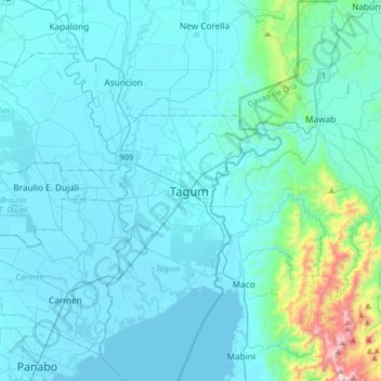
Nombre: Mapa topográfico Tagum, altitud, relieve.
Lugar: Tagum, Davao del Norte, Davao Region, 8100, Philippines (7.28702 125.65118 7.60702 125.97118)
Altitud media: 103 m
Altitud mínima: 0 m
Altitud máxima: 1.143 m