
Mapa topográfico Monticello
Mapa interactivo
Haga clic en el mapa para ver la altitud.
Acerca de este mapa
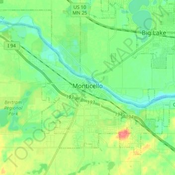
Nombre: Mapa topográfico Monticello, altitud, relieve.
Lugar: Monticello, Wright County, Minnesota, 55362, United States (45.27053 -93.86106 45.33840 -93.73503)
Altitud media: 289 m
Altitud mínima: 270 m
Altitud máxima: 327 m
According to the U.S. Census Bureau, the city has a total area of 8.94 square miles (23.15 km2), all land. The city's latitude is 45.305 degrees North and its longitude is 93.793 degrees West. Its elevation is 922 feet. Monticello is in the Central time zone.
Otros mapas topográficos
Haga clic en un mapa para ver su topografía, su altitud y su relieve.
Rockford
United States > Minnesota > Wright County
Rockford, Wright County, Minnesota, United States
Altitud media: 296 m
Delano
United States > Minnesota > Wright County
Delano, Wright County, Minnesota, 55328, United States
Altitud media: 289 m
Otsego
United States > Minnesota > Wright County
Otsego, Wright County, Minnesota, United States
Altitud media: 281 m
Monticello Township
United States > Minnesota > Wright County
Monticello Township, Wright County, Minnesota, United States
Altitud media: 297 m
Albertville
United States > Minnesota > Wright County
Albertville, Wright County, Minnesota, 55301, United States
Altitud media: 292 m
Hanover
United States > Minnesota > Wright County
Hanover, Wright County, Minnesota, 55341, United States
Altitud media: 291 m
Montrose
United States > Minnesota > Wright County
Montrose, Wright County, Minnesota, United States
Altitud media: 294 m
Howard Lake
United States > Minnesota > Wright County
Howard Lake, Wright County, Minnesota, 55349, United States
Altitud media: 312 m
Buffalo
United States > Minnesota > Wright County
Buffalo, Wright County, Minnesota, 55313, United States
Altitud media: 297 m
Silver Creek Township
United States > Minnesota > Wright County
Silver Creek Township, Wright County, Minnesota, 55380, United States
Altitud media: 303 m
Albion Center
United States > Minnesota > Wright County
Albion Center, Albion Township, Wright County, Minnesota, United States
Altitud media: 320 m
Maple Lake Township
United States > Minnesota > Wright County
Maple Lake Township, Wright County, Minnesota, 55358, United States
Altitud media: 310 m
St. Michael
United States > Minnesota > Wright County
St. Michael, Wright County, Minnesota, 55376, United States
Altitud media: 290 m
South Haven
United States > Minnesota > Wright County
South Haven, Wright County, Minnesota, United States
Altitud media: 333 m
Maple Lake
United States > Minnesota > Wright County > Maple Lake > Maple Lake
Maple Lake, Wright County, Minnesota, 55358, United States
Altitud media: 314 m
South Haven
United States > Minnesota > Wright County > South Haven > South Haven
South Haven, Wright County, Minnesota, 55382, United States
Altitud media: 331 m
Rockford
United States > Minnesota > Wright County > Rockford > Rockford
Rockford, Wright County, Minnesota, 55313:55373, United States
Altitud media: 298 m
Annandale
United States > Minnesota > Wright County > Annandale > Annandale
Annandale, Wright County, Minnesota, 55302, United States
Altitud media: 324 m
Annandale
United States > Minnesota > Wright County
Annandale, Wright County, Minnesota, 55302, United States
Altitud media: 323 m
Maple Lake
United States > Minnesota > Wright County
Maple Lake, Wright County, Minnesota, United States
Altitud media: 314 m