
Mapa topográfico Hayborough
Mapa interactivo
Haga clic en el mapa para ver la altitud.
Acerca de este mapa
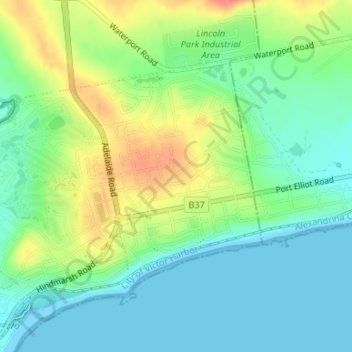
Nombre: Mapa topográfico Hayborough, altitud, relieve.
Altitud media: 23 m
Altitud mínima: 0 m
Altitud máxima: 64 m
Otros mapas topográficos
Haga clic en un mapa para ver su topografía, su altitud y su relieve.
McCracken
Australia > South Australia > City of Victor Harbor
McCracken, City of Victor Harbor, South Australia, 5211, Australia
Altitud media: 25 m
Fleurieu Peninsula
Australia > South Australia > City of Victor Harbor
Fleurieu Peninsula, City of Victor Harbor, South Australia, Australia
Altitud media: 98 m
Granite Island
Australia > South Australia > City of Victor Harbor
Granite Island, City of Victor Harbor, South Australia, Australia
Altitud media: 1 m
Victor Harbor
Australia > South Australia > City of Victor Harbor
Victor Harbor, City of Victor Harbor, South Australia, 5211, Australia
Altitud media: 20 m
Lower Inman Valley
Australia > South Australia > City of Victor Harbor
Lower Inman Valley, City of Victor Harbor, South Australia, 5211, Australia
Altitud media: 99 m
Hindmarsh Tiers
Australia > South Australia > City of Victor Harbor
Hindmarsh Tiers, City of Victor Harbor, South Australia, 5202, Australia
Altitud media: 297 m
Unnamed (No.HA1336) Heritage Agreement
Australia > South Australia > City of Victor Harbor > Inman Valley > Hindmarsh Valley
Unnamed (No.HA1336) Heritage Agreement, Strangways Road, Hindmarsh Valley, Inman Valley, City of Victor Harbor, South Australia, 5211, Australia
Altitud media: 248 m
Hindmarsh Valley
Australia > South Australia > City of Victor Harbor
Hindmarsh Valley, City of Victor Harbor, South Australia, 5211, Australia
Altitud media: 167 m