
Mapa topográfico Humacao
Mapa interactivo
Haga clic en el mapa para ver la altitud.
Humacao
Humacao se encuentra localizado en la costa este; al norte de Yabucoa, al este de Las Piedras y al sur de Naguabo. Tiene llanuras a lo largo del centro y la costa del municipio, representando elevaciones de entre 100-300 metros de altitud en barrios rurales.
Acerca de este mapa
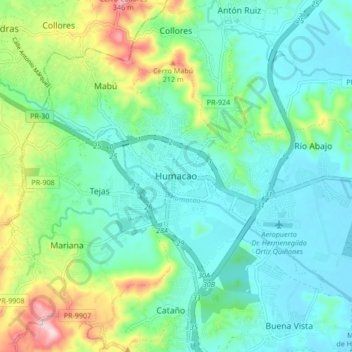
Nombre: Mapa topográfico Humacao, altitud, relieve.
Lugar: Humacao, Puerto Rico, 00792, Estados Unidos de América (18.10918 -65.86501 18.18918 -65.78501)
Altitud media: 78 m
Altitud mínima: 0 m
Altitud máxima: 312 m