
Haz una donación
Mapa topográfico Bigwin Island
Haga clic en el mapa para ver la altitud.
Haz una donación
Acerca de este mapa
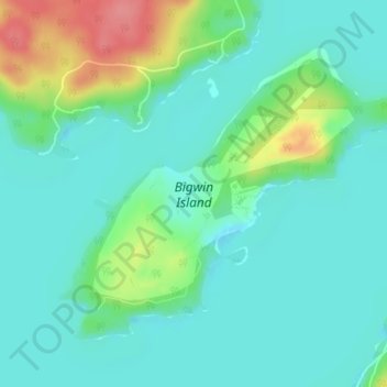
Nombre: Mapa topográfico Bigwin Island, altitud, relieve.
Altitud media: 328 m
Altitud mínima: 307 m
Altitud máxima: 389 m
Haz una donación
Otros mapas topográficos
Haga clic en un mapa para ver su topografía, su altitud y su relieve.
Toronto
Despite its deep ravines, Toronto is not remarkably hilly, but its elevation does increase steadily away from the lake. Elevation differences range from 76.5 metres (251 ft) above sea level at the Lake Ontario shore to 209 m (686 ft) ASL near the York University grounds in the city's north end at the…
Altitud media: 113 m
Ottawa
Ottawa, the capital city of Canada, is situated on the south bank of the Ottawa River at the confluence with the Rideau River. The city's topography is characterized by gently rolling terrain with elevations ranging from approximately 44 meters (144 feet) above sea level at the Ottawa River to its highest…
Altitud media: 105 m
Toronto
Despite its deep ravines, Toronto is not remarkably hilly, but its elevation does increase steadily away from the lake. Elevation differences range from 76.5 metres (251 ft) above sea level at the Lake Ontario shore to 209 m (686 ft) above sea level near the York University grounds in the city's north end at…
Altitud media: 139 m
Peterborough
Canada > Ontario > Peterborough
Peterborough's topography is largely defined by land formations created by the receding Wisconsian glaciers 10,000–15,000 years ago. The South End and Downtown portions of the City sit on what was the bottom of the glacial Lake Peterborough—part of a glacial spillway created when glacial meltwaters from…
Altitud media: 235 m
Haz una donación
Guelph
This region of Ontario has cold winters and warm, humid summers, falling into the Köppen climate classification Dfb zone, with moderately high rainfall and snowfall. It is generally a couple of degrees cooler than lower elevation regions on the Great Lakes shorelines, especially so in winter, the exception…
Altitud media: 344 m
Haz una donación
London
Canada > Ontario > London > London
London has a humid continental climate (Köppen Dfb), though due to its downwind location relative to Lake Huron and elevation changes across the city, it is virtually on the Dfa/Dfb (hot summer) boundary favouring the former climate zone to the southwest of the confluence of the South and North Thames Rivers,…
Altitud media: 268 m
Haz una donación
Lake Ontario
Lake Ontario is the easternmost of the Great Lakes and the smallest in surface area (7,340 sq mi, 18,960 km2), although it exceeds Lake Erie in volume (393 cu mi, 1,639 km3). It is the 13th largest lake in the world. When its islands are included, the lake's shoreline is 712 miles (1,146 km) long. As the last…
Altitud media: 214 m
Toronto
Despite its deep ravines, Toronto is not remarkably hilly, but its elevation does increase steadily away from the lake. Elevation differences range from 76.5 metres (251 ft) above sea level at the Lake Ontario shore to 209 m (686 ft) ASL near the York University grounds in the city's north end at the…
Altitud media: 139 m
Haz una donación
Haz una donación
Haz una donación
Rideau River
Canada > Ontario > Leeds and Grenville Counties > Merrickville > Merrickville-Wolford
Altitud media: 109 m
Haz una donación
Barrie
On September 7, 1977, a private aircraft, flown by "Army" Hollingsworth, dropped altitude to 500 feet (152 m) in dense fog and struck CKVR's 1,000-foot (305 m) transmitter tower, killing all five people aboard the plane and destroying the tower and antenna. The station's 225-foot (69 m) auxiliary tower was…
Altitud media: 265 m
Haz una donación
Michipicoten Island Provincial Park
Canada > Ontario > Unorganized Thunder Bay District
Altitud media: 199 m
Haz una donación
Haz una donación
Kitchener
Canada > Ontario > Region of Waterloo
Kitchener is located in Southwestern Ontario, in the Saint Lawrence Lowlands. This geological and climatic region has wet-climate soils and deciduous forests. Situated in the Grand River Valley, the area is generally above 300 m (1,000 ft) in elevation.
Altitud media: 336 m
Haz una donación
Peterborough
Peterborough's topography is largely defined by land formations created by the receding Wisconsian glaciers 10,000–15,000 years ago. The South End and Downtown portions of the city sit on what was the bottom of the glacial Lake Peterborough—part of a glacial spillway created when glacial meltwaters from…
Altitud media: 232 m
Haz una donación
Haz una donación
Markham
Canada > Ontario > York Region
Markham's average altitude is at 200 m (660 ft) and in general consists of gently rolling hills. The city is intersected by two rivers; the Don River and Rouge River, as well as their tributaries. To the north is the Oak Ridges Moraine, which further elevates the elevation towards the north.
Altitud media: 216 m
Haz una donación
Hamilton
The airport's open, rural location and higher altitude results in lower temperatures, generally windier conditions, and higher snowfall amounts than lower, built-up areas of the city. The highest temperature ever recorded in Hamilton was 41.1 °C (106 °F) on July 14, 1868. The coldest temperature ever…
Altitud media: 187 m
Haz una donación
Lake Nipissing
Canada > Ontario > Nipissing District
Lake Nipissing (/ˈnɪpəsɪŋ/; French: lac Nipissing, Ojibwe: Gichi-nibiinsing-zaaga’igan) is a lake in the Canadian province of Ontario. It has a surface area of 873.3 km2 (337.2 sq mi), a mean elevation of 196 m (643 ft) above sea level, and is located between the Ottawa River and Georgian Bay. Lake…
Altitud media: 272 m
Haz una donación
Scarborough
Topographically, Scarborough is dominated by two watersheds, Highland Creek and the Rouge River. Highland Creek lies almost entirely within Scarborough and occupies approximately 70% of its total area. It occupies the western half of Scarborough, while the Rouge River flows through the eastern portion. Both of…
Altitud media: 138 m
Haz una donación
Simcoe County
The road network in Simcoe County is based on a grid pattern, with most roads running north–south or east–west. The topography of the land has permitted roads to be set in predominantly straight lines.
Altitud media: 265 m
Richmond Hill
Canada > Ontario > York Region
The village of Richmond Hill was incorporated by a bylaw of the York County Council on June 18, 1872, coming into effect January 1, 1873. In September 1956, the Ontario Municipal Board approved its elevation to Town status, effective January 1, 1957.
Altitud media: 256 m
North Bay
Canada > Ontario > Nipissing District
The climate in North Bay is common to most places in Northern Ontario. North Bay tends to be a less humid climate than that found in Southern Ontario due somewhat to the distance from the Great Lakes and less warm than some other locations in Northern Ontario due to cooling from Lake Nipissing. On May 31,…
Altitud media: 266 m
Haz una donación
Haz una donación
Haz una donación
Deep River
Canada > Ontario > Renfrew County
John Bland, an architecture professor at McGill University, developed the town's first master plan in 1944. Bland located the town between the existing Highway 17 and the Ottawa River. He designed a system of streets which generally followed the contours of the area's topography. Residential neighborhoods…
Altitud media: 169 m
Haz una donación
Haz una donación
Niagara River
Canada > Ontario > Niagara Region > Niagara Falls
The river, occasionally described as a strait, is approximately 58 kilometres (36 mi) long and includes Niagara Falls. Over the past 12,000 years, the falls have moved roughly 11 kilometres (6.8 mi) upstream from the leading edge of the Niagara Escarpment, creating a gorge below the falls. Today, the diversion…
Altitud media: 177 m
Haz una donación
Haz una donación
Millbrook
Canada > Ontario > Peterborough County > Cavan-Monaghan
Peterborough's topography is largely defined by land formations created by the receding Wisconsian glaciers 10,000–15,000 years ago. The South End and Downtown portions of the city sit on what was the bottom of the glacial Lake Peterborough—part of a glacial spillway created when glacial meltwaters from…
Altitud media: 250 m
Recollet Falls
Canada > Ontario > Parry Sound District > Unorganized Centre Parry Sound
Altitud media: 206 m
Haz una donación