
Mapa topográfico Albay
Mapa interactivo
Haga clic en el mapa para ver la altitud.
Acerca de este mapa
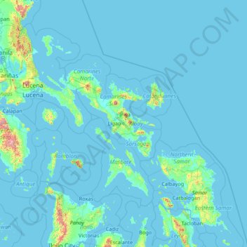
Nombre: Mapa topográfico Albay, altitud, relieve.
Lugar: Albay, Bicol Region, Philippines (10.61667 120.95000 15.81667 126.15000)
Altitud media: 48 m
Altitud mínima: -2 m
Altitud máxima: 2.428 m
Otros mapas topográficos
Haga clic en un mapa para ver su topografía, su altitud y su relieve.
Manila
Almost all of Manila sits on top of centuries of prehistoric alluvial deposits built by the waters of the Pasig River and on some land reclaimed from Manila Bay. Manila's land has been altered substantially by human intervention, with considerable land reclamation along the waterfronts since the American…
Altitud media: 6 m
Mindoro
Philippines > Occidental Mindoro
Mindoro is the seventh largest and eighth-most populous island in the Philippines. With a total land area of 10,571 km2 ( 4,082 sq.mi ) and has a population of 1,408,454 as of 2020 census. It is located off the southwestern coast of Luzon and northeast of Palawan. Mindoro is divided into two provinces:…
Altitud media: 173 m
Nueva Ecija
The province is the largest in Central Luzon, covering a total area of 5,751.33 square kilometres (2,220.60 sq mi). Its terrain begins with the southwestern marshes near the Pampanga border. It levels off and then gradually increases in elevation to rolling hills as it approaches the mountains of Sierra Madre…
Altitud media: 273 m
Leyte
Mahagnao Volcano Natural Park Located in Burauen, Leyte, about 66 km (41 mi) from Tacloban City, the Mahagnao Volcano Natural Park attracts visitors with its lakes, craters, hot springs, multi-colored mud, virgin forests and lagoon. It was proclaimed as a national park in 1937. Like other regions in the…
Altitud media: 68 m
Cagayan
The eastern coast forms the northern portion of the Sierra Madre mountain range, while the western limits are generally hilly to low in elevation. The central area, dominated by a large valley, forms the lower basin of the country's longest river, the Cagayan. The mouth is located at the northern town of…
Altitud media: 110 m
Albay
The western coast of the province is mountainous but not as prominent as the eastern range with the highest elevation at around 490 metres (1,610 ft). Among these mountains are Mount Catburawan in Ligao and Mount Pantao in Oas.
Altitud media: 71 m
Polangui
known during the early times that the barrio has vas and fertile agricultural land, and because of this, settlers from nearby places migrated to this barrio to venture in agricultural farming. One of the early settlers who migrated to this barrio came from barrio La Medalla, town of Iriga (now a City) of the…
Altitud media: 193 m
Lake Apo
Philippines > Bukidnon > Valencia
Lake Apo is a crater lake in Barangay Guinoyoran in the city of Valencia in Bukidnon province in the Philippines. It is located in a hilly area about 640 metres (2,100 ft) in elevation, about 11 kilometres (6.8 mi) WSW of the city poblacion (town center). Lake Apo was awarded the cleanest inland body of water…
Altitud media: 643 m
Central
In order to make Quezon's dream a reality and to mobilize funds for the land purchase, the People's Homesite Corporation (PHC) was created on October 14, 1938, as a subsidiary of NDC, with an initial capital of ₱2 million. Roces was the chairman of the Board of PHC, and they immediately acquired the vast…
Altitud media: 50 m
1920
Philippines > Rizal > Taytay
The shape of Taytay is rectangular – trapezoidal with gently hilly rolling terrain on its eastern side while relatively flat on its south-western side, including the poblacion. The municipality's highest elevation ranges from 200 to 255 meters which is situated along the inner north-eastern hills of Barangay…
Altitud media: 49 m
La Mesa Eco Park
Covering an area of 33 hectares (82 acres) the public park is located along the natural boundary of the La Mesa Watershed Reservation and its elevation is about 40 metres (130 ft) below than the resorvoir.
Altitud media: 66 m
La Mesa Eco Park
Covering an area of 33 hectares (82 acres) the public park is located along the natural boundary of the La Mesa Watershed Reservation and its elevation is about 40 metres (130 ft) below than the reservoir.
Altitud media: 66 m
Likas Island
West York Island, also known as Likas Island (Filipino: Pulo ng Likas, lit. 'Island of Naturality'; Mandarin Chinese: 西月島/西月岛; pinyin: Xīyuè Dǎo; Vietnamese: đảo Bến Lạc), and several other names. With an area of 18.6 hectares (46 acres), it is the third largest of the naturally…
Altitud media: 0 m
Busuanga
Elevation The municipality's western and central portions are predominantly rough and mountainous with rolling to hilly terrain. A part of this is the Chinabayan Mountain and Wayan Range that still support extensive parches of Molave forest and Cogon grassland (features which are dominant in the locale).…
Altitud media: 16 m
Nabua
Nabua has about 8,803.0600 hectares or 99.42% very low elevation or less than 100 meters elevation and remaining 51.3593 hectares or 0.58% of low elevation or between 100 and 300 meters elevation. Its slope covers about 7,927.3616 hectares or 89.53% which are level to nearly level (0-3%) while the remaining…
Altitud media: 27 m