
Mapa topográfico Hattah
Mapa interactivo
Haga clic en el mapa para ver la altitud.
Acerca de este mapa
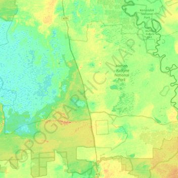
Nombre: Mapa topográfico Hattah, altitud, relieve.
Lugar: Hattah, Rural City of Mildura, Victoria, Australia (-34.86449 142.04149 -34.55750 142.52086)
Altitud media: 49 m
Altitud mínima: 32 m
Altitud máxima: 82 m
Otros mapas topográficos
Haga clic en un mapa para ver su topografía, su altitud y su relieve.
Dandenong Ranges
Australia > Victoria > Melbourne
The topography consists of a series of ridges dissected by deeply cut streams. Sheltered gullies in the south of the range are home to temperate rain forest, fern gullies and Mountain Ash forest Eucalyptus regnans, whereas the drier ridges and exposed northern slopes are covered by dry sclerophyll forest of…
Altitud media: 456 m
Australian Garden - Royal Botanic Gardens Cranbourne
Australia > Victoria > Melbourne
Altitud media: 70 m
Narre Warren North Retarding Basin (Melbourne Water)
Australia > Victoria > Melbourne
Altitud media: 76 m