
Mapa topográfico Nose Hill Park
Mapa interactivo
Haga clic en el mapa para ver la altitud.
Nose Hill Park
Names currently associated with topographical features in and near Nose Hill Park reflect the impact of the European newcomers and European trade goods on the Peigan. For example, Spy Hill, the westward extension of Nose Hill, derived its present name from the aboriginal practice of communicating with distant colleagues by flashing European trade mirrors from elevated locations. Other effects of the Europeans' arrival were more insidious. The six bison that the Methodist missionaries shot during their ill-fated hunting excursion were mere remnants of southern Alberta's once vast buffalo population. By 1879, the bison herds had vanished from Nose Hill. A new chapter of local history had begun. A fledgling Euro-Canadian community, Fort Calgary, had appeared in the valley beneath Nose Hill.
Acerca de este mapa
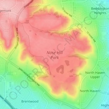
Nombre: Mapa topográfico Nose Hill Park, altitud, relieve.
Lugar: Nose Hill Park, Calgary, Alberta, T3K 2P6, Canada (51.09000 -114.13938 51.13267 -114.08322)
Altitud media: 1.174 m
Altitud mínima: 1.093 m
Altitud máxima: 1.248 m
Otros mapas topográficos
Haga clic en un mapa para ver su topografía, su altitud y su relieve.