
Mapa topográfico Poulton
Mapa interactivo
Haga clic en el mapa para ver la altitud.
Acerca de este mapa
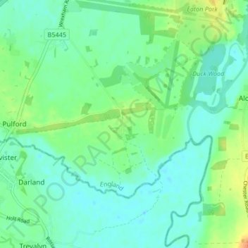
Nombre: Mapa topográfico Poulton, altitud, relieve.
Altitud media: 14 m
Altitud mínima: 4 m
Altitud máxima: 37 m
Otros mapas topográficos
Haga clic en un mapa para ver su topografía, su altitud y su relieve.
Countess of Chester Country Park
United Kingdom > England > Cheshire West and Chester > Chester
Countess of Chester Country Park, Upton-by-Chester, Chester, Cheshire West and Chester, England, CH1 4BE, United Kingdom
Altitud media: 21 m
Roman Fort
United Kingdom > England > Cheshire West and Chester > Chester
Roman Fort, Sandy Lane, Caldy Valley, Huntington, Chester, Cheshire West and Chester, North West England, England, CH3 6GS, United Kingdom
Altitud media: 21 m
Chester Castle
United Kingdom > England > Cheshire West and Chester > Chester
Chester Castle, City Walls, Chester Castle, Chester, Cheshire West and Chester, North West England, England, CH1 1SG, United Kingdom
Altitud media: 18 m