
Mapa topográfico Ghost Lake
Mapa interactivo
Haga clic en el mapa para ver la altitud.
Acerca de este mapa
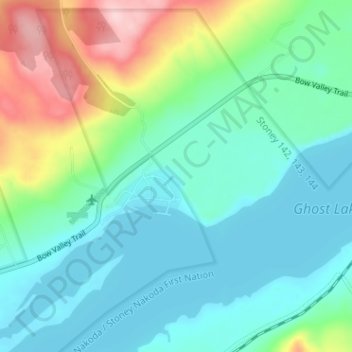
Nombre: Mapa topográfico Ghost Lake, altitud, relieve.
Lugar: Ghost Lake, Division No. 15, Alberta, Canada (51.18798 -114.77853 51.22798 -114.73853)
Altitud media: 1.241 m
Altitud mínima: 1.189 m
Altitud máxima: 1.395 m
Otros mapas topográficos
Haga clic en un mapa para ver su topografía, su altitud y su relieve.
Johnston Creek
Canada > Alberta > Division No. 15
Johnston Creek originates north of Castle Mountain in a glacial valley southwest of Badger Pass and south of Pulsatilla Pass, at an elevation of 2,500 meters (8,200 ft). The creek flows southeast between Helena Ridge and the Sawback Range, and then south through a gorge known as Johnston Canyon. The stream…
Altitud media: 2.126 m
Etherington Creek Provincial Recreation Area
Canada > Alberta > Division No. 15
Altitud media: 1.749 m