
Mapa topográfico Kings Park
Mapa interactivo
Haga clic en el mapa para ver la altitud.
Acerca de este mapa
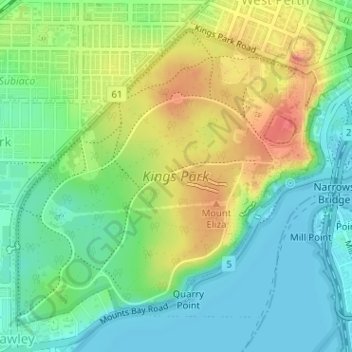
Nombre: Mapa topográfico Kings Park, altitud, relieve.
Altitud media: 31 m
Altitud mínima: 0 m
Altitud máxima: 81 m
Otros mapas topográficos
Haga clic en un mapa para ver su topografía, su altitud y su relieve.
Langley Park
Australia > Western Australia > City of Perth > Perth
Langley Park, East Perth, Perth, City of Perth, Western Australia, Australia
Altitud media: 9 m
Crawley
Australia > Western Australia > City of Perth > Perth
Crawley, Perth, City of Perth, Western Australia, 6009, Australia
Altitud media: 13 m
Northbridge
Australia > Western Australia > City of Perth > Perth
Northbridge, Perth, City of Perth, Western Australia, 6003, Australia
Altitud media: 24 m
Russell Square
Australia > Western Australia > City of Perth > Perth
Russell Square, Northbridge, Perth, City of Perth, Western Australia, Australia
Altitud media: 25 m
Acacia Garden
Australia > Western Australia > City of Perth > Perth
Acacia Garden, Kings Park, Perth, City of Perth, Western Australia, 6005, Australia
Altitud media: 27 m