
Mapa topográfico Denton
Mapa interactivo
Haga clic en el mapa para ver la altitud.
Acerca de este mapa
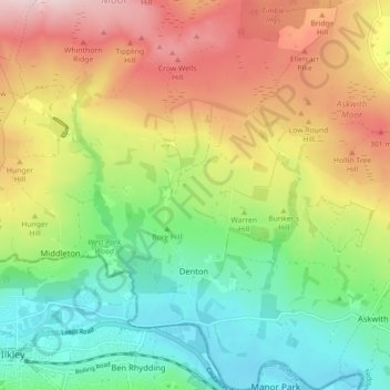
Nombre: Mapa topográfico Denton, altitud, relieve.
Altitud media: 189 m
Altitud mínima: 62 m
Altitud máxima: 364 m
Otros mapas topográficos
Haga clic en un mapa para ver su topografía, su altitud y su relieve.
Galphay
United Kingdom > England > North Yorkshire > Harrogate > Galphay
Galphay, Azerley, Harrogate, North Yorkshire, Yorkshire and the Humber, England, HG4 3NJ, United Kingdom
Altitud media: 120 m
Fewston
United Kingdom > England > North Yorkshire > Harrogate > Fewston
Fewston, Harrogate, North Yorkshire, Yorkshire and the Humber, England, United Kingdom
Altitud media: 205 m
Beckwithshaw
United Kingdom > England > North Yorkshire > Harrogate > Beckwithshaw
Beckwithshaw, Harrogate, North Yorkshire, Yorkshire and the Humber, England, HG3 1QW, United Kingdom
Altitud media: 161 m
Bilton-in-Ainsty with Bickerton
United Kingdom > England > North Yorkshire > Harrogate > Bickerton
Bilton-in-Ainsty with Bickerton, Bickerton, Harrogate, North Yorkshire, Yorkshire and the Humber, England, United Kingdom
Altitud media: 28 m