
Haz una donación
Mapa topográfico Meridian Peak
Haga clic en el mapa para ver la altitud.
Haz una donación
Meridian Peak
Meridian Peak can be found at the southern end of Elliot Ridge Trail. It can be reached by ascending several hiking trails into the Gore Range. Surprise Lake Trail goes south for 2.6 miles to Surprise Lake, then the Gore Range Trail continues west for 1.9 miles to a junction with the Upper Cataract Lake and Mirror Lake Trail. Mirror Lake is 6.5 miles beyond the junction, at an elevation of 10,560 feet. The Elliot Ridge Trail is 3.2 miles from Mirror Lake. The summit of Meridian Peak is another 1.2 south from the junction with the Elliot Ridge Trail.
Haz una donación
Acerca de este mapa
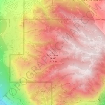
Nombre: Mapa topográfico Meridian Peak, altitud, relieve.
Altitud media: 1.698 m
Altitud mínima: 1.295 m
Altitud máxima: 1.884 m
Haz una donación
Otros mapas topográficos
Haga clic en un mapa para ver su topografía, su altitud y su relieve.
Jordan River OHV/ Modelport State Park
United States > Utah > Salt Lake County > Salt Lake City
Altitud media: 1.286 m