Geolocalizar
👉 Easily get elevation data in JSON, GeoTIFF and KML formats using Elevation API
Gracias por apoyar a este sitio ❤️
Haz una donación

Mapa topográfico Kedarnath

Haga clic en el mapa para ver la altitud.

👉 Easily get elevation data in JSON, GeoTIFF and KML formats using Elevation API
Gracias por apoyar a este sitio ❤️
Haz una donación

Acerca de este mapa

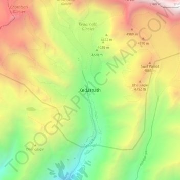
Nombre: Mapa topográfico Kedarnath, altitud, relieve.

Lugar: Kedarnath, Ukhimath, Rudraprayag, Uttarakhand, India (30.69389 79.02691 30.77389 79.10691)

Altitud media: 4.208 m

Altitud mínima: 2.731 m

Altitud máxima: 6.044 m

Otros mapas topográficos

Haga clic en un mapa para ver su topografía, su altitud y su relieve.

Chorabari Glacier

India > Uttarakhand > Ukhimath > Kedarnath

Altitud media: 5.011 m

Lake Vasuki Tal

India > Uttarakhand > Ukhimath > Kedarnath

Altitud media: 4.303 m

Lake Vasuki Tal

India > Uttarakhand > Ukhimath > Kedarnath

Altitud media: 4.303 m