
Gracias por apoyar a este sitio ❤️
Haz una donación
Haz una donación
Mapa topográfico Barron River
Haga clic en el mapa para ver la altitud.
Gracias por apoyar a este sitio ❤️
Haz una donación
Haz una donación
Barron River
The Barron's headwaters start in the Mount Hypipamee National Park near Mount Hypipamee at an elevation of 1,200 metres (3,900 ft). The river then flows north 65 kilometres (40 mi) across the Atherton Tablelands before finally turning east after Mareeba towards Kuranda. After passing under the Kuranda Range Highway's bridge and through Kuranda proper, it descends down the 260-metre (850 ft)-high Barron Falls and reaches the Cairns floodplains near Smithfield. The Dinner Falls are located along the upper Barron River.
Gracias por apoyar a este sitio ❤️
Haz una donación
Haz una donación
Acerca de este mapa
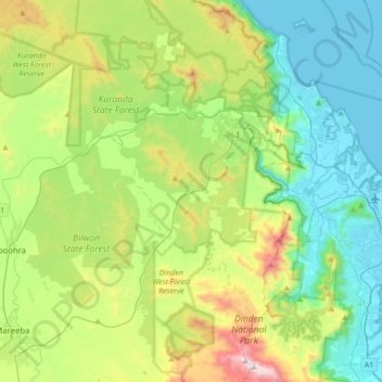
Nombre: Mapa topográfico Barron River, altitud, relieve.
Altitud media: 360 m
Altitud mínima: 0 m
Altitud máxima: 1.284 m
Gracias por apoyar a este sitio ❤️
Haz una donación
Haz una donación