
Gracias por apoyar a este sitio ❤️
Haz una donación
Haz una donación
Mapa topográfico Mouthe
Haga clic en el mapa para ver la altitud.
Gracias por apoyar a este sitio ❤️
Haz una donación
Haz una donación
Mouthe
Due to its elevation and its location in a coomb, the diurnal temperature variation is high and Mouthe features a warm-summer humid continental climate (Dfb, according to the Köppen climate classification), with an average annual precipitation of 1,712.9 mm (67.44 in).
Gracias por apoyar a este sitio ❤️
Haz una donación
Haz una donación
Acerca de este mapa
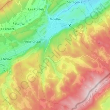
Nombre: Mapa topográfico Mouthe, altitud, relieve.
Altitud media: 1.139 m
Altitud mínima: 921 m
Altitud máxima: 1.410 m
Gracias por apoyar a este sitio ❤️
Haz una donación
Haz una donación
Otros mapas topográficos
Haga clic en un mapa para ver su topografía, su altitud y su relieve.