
Mapa topográfico Zouch
Mapa interactivo
Haga clic en el mapa para ver la altitud.
Acerca de este mapa
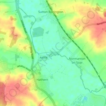
Nombre: Mapa topográfico Zouch, altitud, relieve.
Altitud media: 49 m
Altitud mínima: 26 m
Altitud máxima: 83 m
Most of the hamlet lies in the civil parish of Sutton Bonington, apart from Zouch Farm which falls within Normanton on Soar parish, and the part in Leicestershire which is in Hathern parish. The nearest town is Loughborough. The A6006 road passes through the hamlet and crosses the Soar on Zouch Bridge (alternatively "County Bridge" as it spans the county border). The elevation of Zouch is 30 metres (98 ft).