
Haz una donación
Mapa topográfico Folsom
Haga clic en el mapa para ver la altitud.
Haz una donación
Folsom
Carpenter Hill in Folsom has the highest elevation in Sacramento County.
Haz una donación
Acerca de este mapa
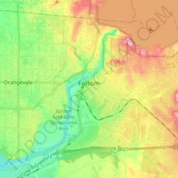
Nombre: Mapa topográfico Folsom, altitud, relieve.
Lugar: Folsom, Sacramento County, California, United States (38.61044 -121.21010 38.71736 -121.07908)
Altitud media: 90 m
Altitud mínima: 21 m
Altitud máxima: 217 m
Haz una donación
Otros mapas topográficos
Haga clic en un mapa para ver su topografía, su altitud y su relieve.
Haz una donación
Haz una donación
Haz una donación
Walnut Grove
United States > California > Sacramento County
Walnut Grove's location has made it the site of a rare collection of very tall radio and television transmission towers. The first major tower here was the KXTV/KOVR/KCRA Tower built in 1962, which dominated the skyline for over twenty years with its 1,548 foot height. In 1985 the old tower was joined by…
Altitud media: 1 m
Haz una donación
Haz una donación
Haz una donación
Haz una donación
Haz una donación
Haz una donación