
Haz una donación
Mapa topográfico Cambrai
Haga clic en el mapa para ver la altitud.
Haz una donación
Cambrai
Precipitation is distributed year-round, with highs in the spring and autumn, with February being the driest month. Contrasting with the rainy image of the region, the total annual precipitation is relatively small with 642 millimetres (25.3 in) at Cambrai-Épinoy; identical to the Montsouris Paris station, which is at the same altitude, it is less than those of Toulouse at 656 millimetres (25.8 in) or Nice at 767 millimetres (30.2 in). However, the number of days of rain (63 in Nice, 120 in Cambrai) confirms the oceanic character of the climate.
Haz una donación
Acerca de este mapa
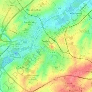
Nombre: Mapa topográfico Cambrai, altitud, relieve.
Altitud media: 67 m
Altitud mínima: 40 m
Altitud máxima: 102 m
Haz una donación
Otros mapas topográficos
Haga clic en un mapa para ver su topografía, su altitud y su relieve.
Haz una donación
Haz una donación