
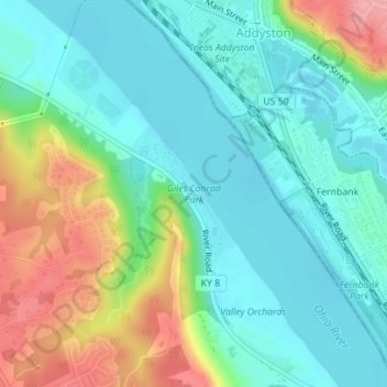
Mapa topográfico Giles Conrad Park
Mapa interactivo
Haga clic en el mapa para ver la altitud.
Acerca de este mapa
Nombre: Mapa topográfico Giles Conrad Park, altitud, relieve.
Altitud media: 172 m
Altitud mínima: 138 m
Altitud máxima: 250 m
Otros mapas topográficos
Haga clic en un mapa para ver su topografía, su altitud y su relieve.
Shawnee National Forest
United States of America > Kentucky > Tiline
Shawnee National Forest, Casey Lane, Tiline, Livingston County, Kentucky, 42083, United States of America
Altitud media: 132 m
Park Hills
United States of America > Kentucky > Park Hills
Park Hills, Kenton County, Kentucky, United States of America
Altitud media: 226 m
Barren River Lake
United States of America > Kentucky > Cedar Springs
Barren River Lake, Hurricane Shores Road, Cedar Springs, Allen County, Kentucky, 42156, United States of America
Altitud media: 193 m
Fulton
United States of America > Kentucky > Fulton
Fulton, Fulton County, Kentucky, United States of America
Altitud media: 124 m
Yellowbank Creek
United States of America > Kentucky > Manning Crossing
Yellowbank Creek, Manning Crossing, Breckinridge County, Kentucky, United States of America
Altitud media: 152 m
Stevens Knob
United States of America > Kentucky
Stevens Knob, Powell County, Kentucky, United States of America
Altitud media: 227 m
Renfro Valley
United States of America > Kentucky > Mount Vernon > Renfro Valley
Renfro Valley, Mount Vernon, Rockcastle County, Kentucky, 40473, United States of America
Altitud media: 341 m
Ellwood
United States of America > Kentucky > Ellwood
Virgie, Ellwood, Pike County, Kentucky, 41538, United States of America
Altitud media: 375 m
Clifty
United States of America > Kentucky > Clifty
Clifty, Todd County, Kentucky, 42216, United States of America
Altitud media: 225 m
Alum Springs
United States of America > Kentucky > Alum Springs
Alum Springs, Boyle County, Kentucky, 40422:40440, United States of America
Altitud media: 341 m
Marydale
United States of America > Kentucky > Marydale
Marydale, Boone County, Kentucky, 41018, United States of America
Altitud media: 267 m
Golden Ash
United States of America > Kentucky > Golden Ash
Kitts, Golden Ash, Harlan County, Kentucky, 40806, United States of America
Altitud media: 528 m
Lovely
United States of America > Kentucky > Lovely
Lovely, Martin County, Kentucky, 25674, United States of America
Altitud media: 266 m
Honeybee
United States of America > Kentucky > Honeybee
Honeybee, McCreary County, Kentucky, 42634, United States of America
Altitud media: 337 m
Ashbrook
United States of America > Kentucky > Ashbrook
Ashbrook, Anderson County, Kentucky, United States of America
Altitud media: 239 m
Raley Ford
United States of America > Kentucky > Raley Ford
Raley Ford, Allen County, Kentucky, United States of America
Altitud media: 183 m
Murray Hill
United States of America > Kentucky > Murray Hill
Murray Hill, Jefferson County, Kentucky, United States of America
Altitud media: 194 m
Claryville
United States of America > Kentucky > Claryville
Claryville, Campbell County, Kentucky, United States of America
Altitud media: 217 m
Stonewall Estates
United States of America > Kentucky > Lexington > Stonewall Estates
Stonewall Estates, Lexington, Fayette County, Kentucky, 40390:40513, United States of America
Altitud media: 301 m
Ludlow
United States of America > Kentucky > Ludlow
Ludlow, Kenton County, Kentucky, 41016, United States of America
Altitud media: 182 m
Daniel Boone
United States of America > Kentucky > Daniel Boone
Daniel Boone, Hopkins County, Kentucky, 42442, United States of America
Altitud media: 149 m