
Gracias por apoyar a este sitio ❤️
Haz una donación
Haz una donación
Mapa topográfico Barcelonnette
Haga clic en el mapa para ver la altitud.
Gracias por apoyar a este sitio ❤️
Haz una donación
Haz una donación
Barcelonnette
Barcelonnette is situated in the wide and fertile Ubaye Valley, of which it is the largest town. It lies at an elevation of 1132 m (3717 ft) on the right bank of the Ubaye River, and is surrounded by mountains which reach peaks of over 3000 m; the tallest of these is the Needle of Chambeyron at 3412 m. Barcelonnette is situated 210 km from Turin, 91 km from Nice and 68 km from Gap.
Gracias por apoyar a este sitio ❤️
Haz una donación
Haz una donación
Acerca de este mapa
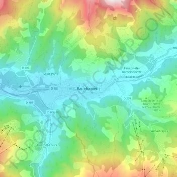
Nombre: Mapa topográfico Barcelonnette, altitud, relieve.
Altitud media: 1.494 m
Altitud mínima: 1.103 m
Altitud máxima: 2.479 m
Gracias por apoyar a este sitio ❤️
Haz una donación
Haz una donación