
Gracias por apoyar a este sitio ❤️
Haz una donación
Haz una donación
Mapa topográfico Redmond
Haga clic en el mapa para ver la altitud.
Gracias por apoyar a este sitio ❤️
Haz una donación
Haz una donación
Redmond
The city encompasses 15.5 square miles (40 km2) and is on a plateau, at an elevation of 3,077 feet (938 m). Redmond is 15 miles (24 km) north of Bend—the county seat of Deschutes County—144 miles (232 km) from Portland, 129 miles (208 km) from Salem—the capital of Oregon—and 126 miles (203 km) from Eugene.
Gracias por apoyar a este sitio ❤️
Haz una donación
Haz una donación
Acerca de este mapa
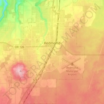
Nombre: Mapa topográfico Redmond, altitud, relieve.
Lugar: Redmond, Deschutes County, Oregon, 97756, United States (44.22580 -121.23475 44.31077 -121.13355)
Altitud media: 921 m
Altitud mínima: 830 m
Altitud máxima: 987 m
Gracias por apoyar a este sitio ❤️
Haz una donación
Haz una donación