
Mapa topográfico Perry County
Mapa interactivo
Haga clic en el mapa para ver la altitud.
Acerca de este mapa
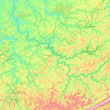
Nombre: Mapa topográfico Perry County, altitud, relieve.
Lugar: Perry County, Kentucky, United States (36.99185 -83.55394 37.44354 -83.00014)
Altitud media: 425 m
Altitud mínima: 232 m
Altitud máxima: 864 m
Otros mapas topográficos
Haga clic en un mapa para ver su topografía, su altitud y su relieve.
Combs
United States > Kentucky > Perry County
Combs, Perry County, Kentucky, 41729, United States
Altitud media: 338 m
Buckhorn
United States > Kentucky > Perry County
Buckhorn, Perry County, Kentucky, United States
Altitud media: 307 m
Hazard
United States > Kentucky > Perry County > Hazard > Hazard
Hazard, Perry County, Kentucky, 41729, United States
Altitud media: 369 m