
Haz una donación
Mapa topográfico Possum Hollow
Haga clic en el mapa para ver la altitud.
Haz una donación
Acerca de este mapa
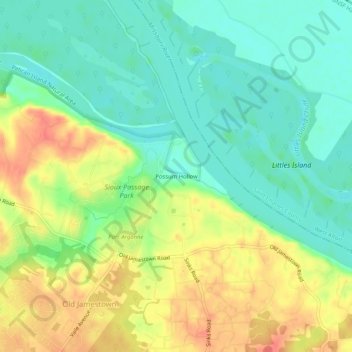
Nombre: Mapa topográfico Possum Hollow, altitud, relieve.
Altitud media: 146 m
Altitud mínima: 122 m
Altitud máxima: 179 m
Haz una donación
Otros mapas topográficos
Haga clic en un mapa para ver su topografía, su altitud y su relieve.
Fenton
United States > Missouri > Saint Louis County
The topography of the Fenton area is predominantly rolling hills.
Altitud media: 149 m
Haz una donación
Haz una donación
Richmond Heights
United States > Missouri > Saint Louis County
Richmond Heights is a city in St. Louis County, Missouri. It is an inner-ring suburb of St. Louis, Missouri, United States. The United States census shows the population grew from 8,603 in 2010 to 9,286 in 2020. According to Robert L. Ramsay, the name was suggested by Robert E. Lee, who thought the topography…
Altitud media: 161 m
Haz una donación
Haz una donación
Haz una donación
Dr. Edmund A. Babler Memorial State Park
United States > Missouri > Saint Louis County > Wildwood
Altitud media: 187 m
Haz una donación
Concord
United States > Missouri > Saint Louis County > Concord > Grantwood Village
Altitud media: 175 m
Haz una donación
Olivette
United States > Missouri > Saint Louis County
Olivette has one of the highest elevations in St. Louis County at 700 feet.
Altitud media: 194 m
Haz una donación
Haz una donación
Dr. Edmund A. Babler Memorial State Park
United States > Missouri > Saint Louis County > Wildwood
Altitud media: 187 m
Haz una donación
Haz una donación
Haz una donación
Haz una donación
Haz una donación
Haz una donación
Haz una donación
Haz una donación
Haz una donación
Haz una donación
Haz una donación
Haz una donación
Olivette
United States > Missouri > Saint Louis County
Olivette has one of the highest elevations in St. Louis County at 700 feet.
Altitud media: 194 m