
Haz una donación
Mapa topográfico Mountain Village
Haga clic en el mapa para ver la altitud.
Haz una donación
Mountain Village
Mountain Village is a home rule municipality in San Miguel County, southwestern Colorado. It is located just southwest of Telluride, Colorado in the San Juan Mountains. The elevation of the town rises above Telluride to 9,600 feet. The population was 1,264 at the 2020 census.
Haz una donación
Acerca de este mapa
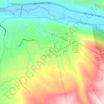
Nombre: Mapa topográfico Mountain Village, altitud, relieve.
Altitud media: 2.917 m
Altitud mínima: 2.629 m
Altitud máxima: 3.341 m
Haz una donación
Otros mapas topográficos
Haga clic en un mapa para ver su topografía, su altitud y su relieve.
Telluride
United States > Colorado > San Miguel County
Telluride has an elevation of 8,750 feet (2,670 m) in an isolated spot in Southwest Colorado. From the west, Colorado Route 145 is the most common way into Telluride; two other passes enter the town, Imogene Pass and Black Bear Pass.
Altitud media: 3.125 m
Haz una donación
Telluride
United States > Colorado > San Miguel County
Telluride has an elevation of 8,750 feet (2,670 m) in an isolated spot in Southwest Colorado. From the west, Colorado Route 145 is the most common way into Telluride; two other passes enter the town, Imogene Pass and Black Bear Pass.
Altitud media: 3.125 m
Haz una donación
Telluride
United States > Colorado > San Miguel County > Telluride
Telluride has an elevation of 8,750 feet (2,670 m) in an isolated spot in Southwest Colorado. From the west, Colorado Route 145 is the most common way into Telluride; two other passes enter the town, Imogene Pass and Black Bear Pass.
Altitud media: 3.246 m
Haz una donación