
Haz una donación
Mapa topográfico Lake Anna
Haga clic en el mapa para ver la altitud.
Haz una donación
Lake Anna
The dam creating the lake, North Anna Dam, is a 5,000-foot-long (1,524 m) and 90-foot-high (27 m) earthen embankment dam. It is 30 feet (9 m) wide at its crest which sits at an elevation of 265 feet (81 m) above sea level. The dam's spillway is located in the center of its body and is 200 feet (61 m) wide, containing three main 40-foot-wide (12 m) and 30-foot-high (9 m) radial gates. Two smaller 8.5-foot (3 m) wide and tall gates on the outer edges of the spillway section maintain normal discharges. Normal elevation for the reservoir is 250 feet (76 m).[3] The dam's hydroelectric power plant is located on the west side of the spillway and is supplied with water via a 5-foot-diameter (2 m) penstock. The plant consists of two small open runner turbine-generators, the larger with a 775 kW capacity and the smaller rated at 225 kW for a combined installed capacity of 1 megawatt.[4][5]
Haz una donación
Acerca de este mapa
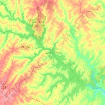
Nombre: Mapa topográfico Lake Anna, altitud, relieve.
Altitud media: 97 m
Altitud mínima: 52 m
Altitud máxima: 154 m
Haz una donación
Otros mapas topográficos
Haga clic en un mapa para ver su topografía, su altitud y su relieve.