
Mapa topográfico Queen Valley
Mapa interactivo
Haga clic en el mapa para ver la altitud.
Acerca de este mapa
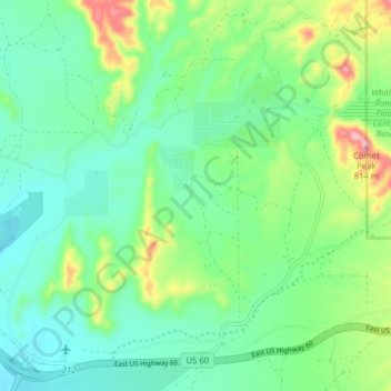
Nombre: Mapa topográfico Queen Valley, altitud, relieve.
Lugar: Queen Valley, Pinal County, Arizona, United States (33.25274 -111.34105 33.31838 -111.26798)
Altitud media: 633 m
Altitud mínima: 568 m
Altitud máxima: 804 m
Queen Valley is located at 33°17′42″N 111°17′52″W / 33.29500°N 111.29778°W / 33.29500; -111.29778. at an elevation of 2000 feet along the south side of the west flowing Queen Creek. The Tonto National Forest boundary and Comet Peak (2681 ft.) lie 1.5 miles to the east. The dam for the Whitlow Ranch Flood Control Basin is one mile to the east.
Otros mapas topográficos
Haga clic en un mapa para ver su topografía, su altitud y su relieve.
San Tan Valley
United States > Arizona > Pinal County
San Tan Valley, Pinal County, Arizona, 85243, United States
Altitud media: 463 m
Casa Grande
United States > Arizona > Pinal County
Casa Grande, Pinal County, Arizona, United States
Altitud media: 439 m
Tiger
United States > Arizona > Pinal County
Tiger, Pinal County, Arizona, 85618, United States
Altitud media: 928 m