
Mapa topográfico Atlantic Highlands
Mapa interactivo
Haga clic en el mapa para ver la altitud.
Acerca de este mapa
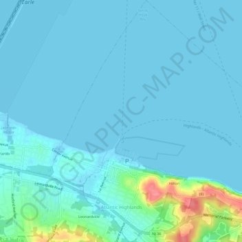
Nombre: Mapa topográfico Atlantic Highlands, altitud, relieve.
Altitud media: 9 m
Altitud mínima: -1 m
Altitud máxima: 78 m
Atlantic Highlands has a humid subtropical climate (Cfa) and average monthly temperatures range from 32.6 °F (0.3 °C) in January to 75.9 °F (24.4 °C) in July. The hardiness zone is 7a or 7b depending upon elevation.
Otros mapas topográficos
Haga clic en un mapa para ver su topografía, su altitud y su relieve.
Tinton Falls
United States > New Jersey > Monmouth County
Tinton Falls, Monmouth County, New Jersey, United States
Altitud media: 23 m
Hazlet Township
United States > New Jersey > Monmouth County
Hazlet Township, Monmouth County, New Jersey, 07730, United States
Altitud media: 15 m
Aberdeen Township
United States > New Jersey > Monmouth County
Aberdeen Township, Monmouth County, New Jersey, United States
Altitud media: 17 m
Keyport
United States > New Jersey > Monmouth County
Keyport, Monmouth County, New Jersey, 07735, United States
Altitud media: 6 m
Matawan
United States > New Jersey > Monmouth County
Matawan, Monmouth County, New Jersey, United States
Altitud media: 20 m
Fletcher Lake
United States > New Jersey > Monmouth County > Bradley Beach
Fletcher Lake, Bradley Beach, Monmouth County, New Jersey, United States
Altitud media: 4 m
Candlewood
United States > New Jersey > Monmouth County > Howell Township > Candlewood
Candlewood, Howell Township, Monmouth County, New Jersey, 07731, United States
Altitud media: 33 m
Middletown Township
United States > New Jersey > Monmouth County
Middletown Township, Monmouth County, New Jersey, United States
Altitud media: 18 m
Ocean Township
United States > New Jersey > Monmouth County
Ocean Township, Monmouth County, New Jersey, 07755, United States
Altitud media: 21 m
Freehold Township
United States > New Jersey > Monmouth County
Freehold Township, Monmouth County, New Jersey, 07728, United States
Altitud media: 41 m