
Mapa topográfico Huntingville
Mapa interactivo
Haga clic en el mapa para ver la altitud.
Acerca de este mapa
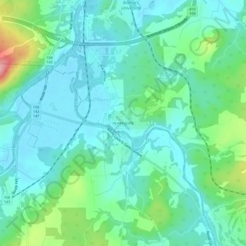
Nombre: Mapa topográfico Huntingville, altitud, relieve.
Altitud media: 176 m
Altitud mínima: 144 m
Altitud máxima: 286 m
Otros mapas topográficos
Haga clic en un mapa para ver su topografía, su altitud y su relieve.
Lennoxville
Canada > Quebec > Sherbrooke
Lennoxville, Sherbrooke, Estrie, Quebec, Canada
Altitud media: 212 m
Parc du Bois-Beckett
Canada > Quebec > Sherbrooke
Parc du Bois-Beckett, Rue Beckett, Les Nations, Sherbrooke, Estrie, Quebec, J1J 3A8, Canada
Altitud media: 214 m
Sherbrooke
Canada > Quebec > Sherbrooke
Sherbrooke, Estrie, Quebec, J1H 1P1, Canada
Altitud media: 249 m