
Mapa topográfico Río Grande
Mapa interactivo
Haga clic en el mapa para ver la altitud.
Acerca de este mapa
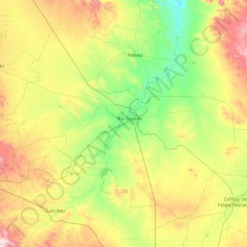
Nombre: Mapa topográfico Río Grande, altitud, relieve.
Lugar: Río Grande, Zacatecas, 98400, Mexico (23.55942 -103.39197 24.06550 -102.67373)
Altitud media: 2.059 m
Altitud mínima: 1.748 m
Altitud máxima: 2.663 m
Over 96% of the municipality's area lies in the drainage basin of the Aguanaval River, the main watercourse in the area which flows south to north through the municipality. This river was known as the Río Grande in the 16th and 17th centuries despite its modest size. The highest point in the municipality is the Cerro Tetilla Grande located at 23°41′N 102°51′W / 23.683°N 102.850°W / 23.683; -102.850 with an elevation of 2,370 metres (7,780 ft) above sea level.
Otros mapas topográficos
Haga clic en un mapa para ver su topografía, su altitud y su relieve.
Pozo Hondo
Mexico > Zacatecas > Villa de Cos
Pozo Hondo, Villa de Cos, Zacatecas, Mexico
Altitud media: 2.032 m