
Mapa topográfico Winter Haven
Haga clic en el mapa para ver la altitud.
Winter Haven
According to the United States Census Bureau, the city has a total area of 25.4 square miles (66 km2), of which 17.7 square miles (46 km2) is land and 7.7 square miles (20 km2) (30.45%) is water. Winter Haven is located within the Central Florida Highlands area of the Atlantic coastal plain with a terrain consisting of flatland interspersed with gently rolling hills. It has an average elevation of 146 feet (45 m) above sea-level. The city is located at the headwaters of the Peace River.
Acerca de este mapa
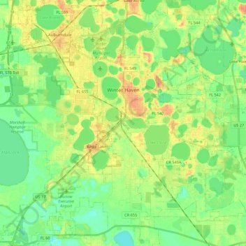
Nombre: Mapa topográfico Winter Haven, altitud, relieve.
Lugar: Winter Haven, Polk County, Florida, 33880, United States (27.90064 -81.77012 28.09222 -81.62766)
Altitud media: 40 m
Altitud mínima: 24 m
Altitud máxima: 61 m
Otros mapas topográficos
Haga clic en un mapa para ver su topografía, su altitud y su relieve.
Allen David Broussard Catfish Creek Preserve State Park
United States > Florida > Polk County
Altitud media: 18 m