
Haz una donación
Mapa topográfico Plush
Haga clic en el mapa para ver la altitud.
Haz una donación
Acerca de este mapa
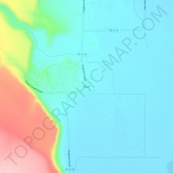
Nombre: Mapa topográfico Plush, altitud, relieve.
Lugar: Plush, Lake County, Oregon, 97637, United States (42.39157 -119.92386 42.43157 -119.88386)
Altitud media: 1.407 m
Altitud mínima: 1.361 m
Altitud máxima: 1.568 m
Haz una donación
Otros mapas topográficos
Haga clic en un mapa para ver su topografía, su altitud y su relieve.
Paisley
United States > Oregon > Lake County
Paisley is located at an elevation of 4,374 feet (1,333 m). According to the United States Census Bureau, the city has a total area of 0.44 square miles (1.14 km2), all of it land. The Chewaucan River flows through the city.
Altitud media: 1.355 m
Summer Lake
United States > Oregon > Lake County
Summer Lake was spotted and named by Captain John C. Frémont during his 1843 mapping expedition through central Oregon. Fremont and his Army topographical team were mapping the Oregon Territory from The Dalles on Columbia River to Sutter's Fort in Sacramento, California. On 16 December 1843, the expedition…
Altitud media: 1.409 m
Lakeview
United States > Oregon > Lake County
Lakeview is a city in Lake County, Oregon, United States. The population was 2,418 at the 2020 census. It is the county seat of Lake County. The city bills itself as the "Tallest Town in Oregon" because of its elevation, 4,757 feet (1,450 m) above sea level. Lakeview is situated in the Goose Lake Valley at the…
Altitud media: 1.562 m
Valley Falls
United States > Oregon > Lake County
In 1832, John Work led his Hudson's Bay Company trapping brigade through the Valley Falls area. Work recorded the visit in his journal. In 1843, Captain John C. Fremont explored the area around Valley Falls. Fremont name Abert Rim and nearby Abert Lake after the head of the United States Army's topographical…
Altitud media: 1.324 m
Haz una donación
Haz una donación