
Haz una donación
Mapa topográfico Behchokǫ̀
Haga clic en el mapa para ver la altitud.
Haz una donación
Behchokǫ̀
As the community grew alongside increased services such as a mission-run hospital and church, the government viewed the topography of Fort Rae as unsuitable for expansion. In the 1950s there was concern about runoff from animal and human wastes contaminating sources of drinking water, and the government proposed constructing a new settlement on more favourable terrain. The community became known as Edzo and was located on the west side of the Frank Channel opposite Fort Rae a 24 km (15 mi) drive away. Most of the Dene families refused to move from their community so that Rae (62°49′43″N 116°03′08″W / 62.82861°N 116.05222°W / 62.82861; -116.05222 (Rae)) and Edzo (62°46′30″N 116°02′26″W / 62.77500°N 116.04056°W / 62.77500; -116.04056 (Edzo)) (Rae-Edzo) became two separate communities although administered together.
Haz una donación
Acerca de este mapa
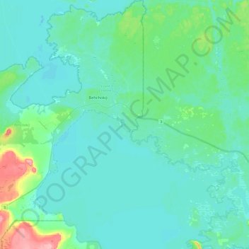
Nombre: Mapa topográfico Behchokǫ̀, altitud, relieve.
Altitud media: 169 m
Altitud mínima: 152 m
Altitud máxima: 257 m
Haz una donación