
Haz una donación
Mapa topográfico Paradise
Haga clic en el mapa para ver la altitud.
Haz una donación
Paradise
Paradise lies within the foothills of the Sierra Nevada mountain range, at an elevation that varies between 900 and 2,300 feet (275 to 700 meters) above sea level. The town is perched on a broad ridge, with steep canyons on either side—these are carved by the Feather River to the east and Butte Creek to the west. This topographical setting creates dramatic views of the surrounding landscape, with steep inclines and rugged terrain. As you move northward from Paradise, the elevation steadily increases, offering sweeping vistas of the nearby valleys. The area is known for its mountainous, forested terrain, which is rich in natural beauty but can be challenging due to its hilly and uneven landscape.
Haz una donación
Acerca de este mapa
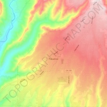
Nombre: Mapa topográfico Paradise, altitud, relieve.
Lugar: Paradise, Butte County, California, 95969, United States (39.72536 -121.65565 39.80154 -121.56445)
Altitud media: 464 m
Altitud mínima: 139 m
Altitud máxima: 726 m
Haz una donación
Otros mapas topográficos
Haga clic en un mapa para ver su topografía, su altitud y su relieve.
Haz una donación
Haz una donación
Haz una donación
Stirling City
United States > California > Butte County
Stirling City is a census-designated place in Butte County, California, located on Paradise Ridge in the western foothills of the Sierra Nevada. Contrary to its name, Stirling City is not a city. Its ZIP Code is 95978 and area code 530. It lies at an elevation of 3570 feet (1088 m). Stirling City had a…
Altitud media: 1.044 m
Haz una donación
Haz una donación
Haz una donación