
Mapa topográfico Gurdaspur
Mapa interactivo
Haga clic en el mapa para ver la altitud.
Acerca de este mapa
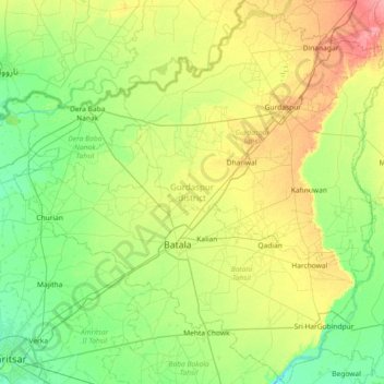
Nombre: Mapa topográfico Gurdaspur, altitud, relieve.
Lugar: Gurdaspur, Punjab, India (31.59387 74.88848 32.21387 75.60134)
Altitud media: 247 m
Altitud mínima: 225 m
Altitud máxima: 294 m
All the Tehsils of the district namely Gurdaspur, Batala and Dera Baba Nanak are plain and similar to the rest of the Punjab plains in structure. The landscape of the district has varied topography comprising undulating plan, the flood plains of the Ravi and the Beas and the upland plain.
Otros mapas topográficos
Haga clic en un mapa para ver su topografía, su altitud y su relieve.